
Magnitude |
:1.8 |
| Date & Time (UTC) | 2012-02-21 01:10:29.5 |
| Date & Time (Local) | 1390/12/2 04:40:29.5 |
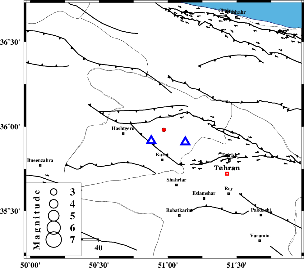
| Location | Lat:35.98 Lon: 50.97 |
| Region | Tehran Province, 20 km North of Karaj |
Nearest Cities |
|
| 5 km North of Barghan, Tehran Province | |
| 14 km North East of Chandar, Tehran Province | |
| 20 km North of Karaj, Tehran Province | |
| 27 km North East of Hashtgerd, Tehran Province | |
| 30 km South East of Shahrak, Tehran Province | |
| Depth | 16 km |
| Agency | |
Faults within 150 km: |
|
| MOSHA_F (Length: 234 km) , Distance to epicenter: 9 km | |
| N_TEHRAN_F4 (Length: 115 km) , Distance to epicenter: 13 km | |
| TALEGHAN_F (Length: 71 km) , Distance to epicenter: 15 km | |
| Number of Phases | 5 |
| RMS | 0.2 |
| Number of Stations | 4 |
| Error in Latitude | >4.2 km |
| Error in Longitude | 3.5 km |
| Error in Depth | 3.1 km |
Download waveform in seisan format
to download seisan software Click here
to access information about IIEES stations Click here
Amplitude | ||||||||
| UID | Agency | Station | Component | Amplitude | Period | Arrival Time | Proccessing Time | Signal Clip |
| 81946 | IIEES | CHTH | E | 165.5 | 0.03 | 2012-02-21 01:10:37 | 2012-02-21 12:19:00 | n |
| 81947 | IIEES | GHVR | N | 12.3 | 0.2 | 2012-02-21 01:11:20 | 2012-02-21 12:19:00 | n |
| 81948 | IIEES | GHVR | E | 17.9 | 0.44 | 2012-02-21 01:11:24 | 2012-02-21 12:19:00 | n |
| 81949 | IIEES | ASAO | N | 10.2 | 0.36 | 2012-02-21 01:11:24 | 2012-02-21 12:19:00 | n |
Phase | ||||||||||||
| Agency | Station | Component | Phase Type | Phase Quality | First Motion | Observed Arrival Time | Time Residual | Loc. Flag | Input Weight | Distance | Azimuth | |
| IIEES | THKV | Z | Pg | E | 2012-02-21 01:10:33 | -0.07 | y | 10.8 | 226 | |||
| IIEES | CHTH | Z | Pg | E | 2012-02-21 01:10:34 | 0.29 | y | 16.8 | 120 | |||
| IIEES | CHTH | E | Sg | E | 2012-02-21 01:10:36 | -0.18 | y | 16.8 | 120 | |||
| IIEES | ASAO | Z | Pn | E | 2012-02-21 01:10:59 | -0.11 | y | 181 | 208 | |||
| IIEES | ASAO | N | Sg | E | 2012-02-21 01:11:21 | 0.08 | y | 181 | 208 | |||