
Magnitude |
:2 |
| Date & Time (UTC) | 2012-02-17 07:08:17.4 |
| Date & Time (Local) | 1390/11/28 10:38:17.4 |
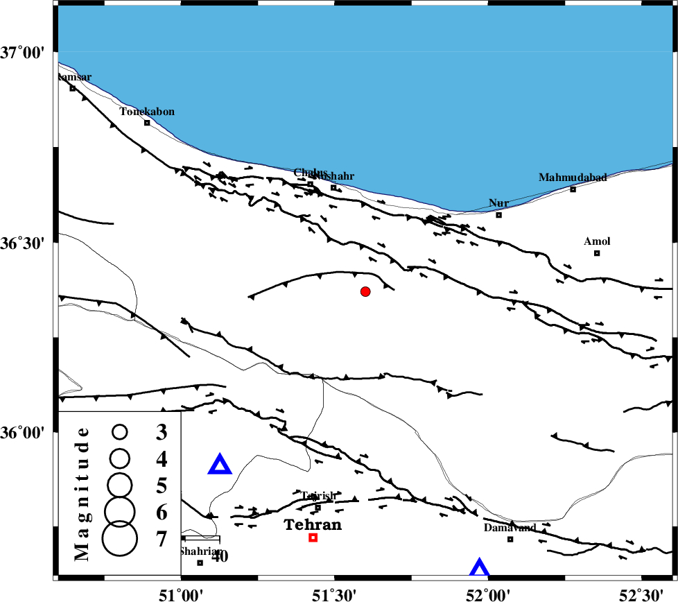
| Location | Lat:36.37 Lon: 51.6 |
| Region | Mazandaran Province, 32 km South of Nowshahr |
Nearest Cities |
|
| 4 km of Pul, Mazandaran Province | |
| 11 km West of Kujur, Mazandaran Province | |
| 15 km North of Void, Mazandaran Province | |
| 26 km South West of Andarud, Mazandaran Province | |
| 27 km North West of Baladeh, Mazandaran Province | |
| Depth | 14 km |
| Agency | |
Faults within 150 km: |
|
| KOJOOR (Length: 75 km) , Distance to epicenter: 5 km | |
| N_ALBORZ_F (Length: 360 km) , Distance to epicenter: 11 km | |
| KHAZAR_F (Length: 523 km) , Distance to epicenter: 23 km | |
| Number of Phases | 6 |
| RMS | 0.1 |
| Number of Stations | 4 |
| Error in Latitude | >4.3 km |
| Error in Longitude | 5.5 km |
| Error in Depth | 5.4 km |
Download waveform in seisan format
to download seisan software Click here
to access information about IIEES stations Click here
Amplitude | ||||||||
| UID | Agency | Station | Component | Amplitude | Period | Arrival Time | Proccessing Time | Signal Clip |
| 81907 | IIEES | THKV | N | 44 | 0.28 | 2012-02-17 07:08:45 | 2012-02-17 07:54:00 | n |
| 81908 | IIEES | THKV | E | 41.3 | 0.36 | 2012-02-17 07:08:45 | 2012-02-17 07:54:00 | n |
| 81909 | IIEES | GHVR | E | 17.5 | 0.76 | 2012-02-17 07:09:28 | 2012-02-17 07:54:00 | n |
| 81910 | IIEES | GHVR | N | 15.2 | 0.52 | 2012-02-17 07:09:28 | 2012-02-17 07:54:00 | n |
Phase | ||||||||||||
| Agency | Station | Component | Phase Type | Phase Quality | First Motion | Observed Arrival Time | Time Residual | Loc. Flag | Input Weight | Distance | Azimuth | |
| IIEES | CHTH | Z | Pg | E | 2012-02-17 07:08:29 | -0.2 | y | 66.5 | 220 | |||
| IIEES | THKV | Z | Pg | E | 2012-02-17 07:08:31 | 0.06 | y | 81.9 | 232 | |||
| IIEES | THKV | E | Sg | E | 2012-02-17 07:08:42 | -0.01 | y | 81.9 | 232 | |||
| IIEES | GHVR | Z | Pn | E | 2012-02-17 07:08:51 | 0 | y | 212 | 189 | |||
| IIEES | ASAO | Z | Pn | E | 2012-02-17 07:08:56 | 0.11 | y | 247 | 216 | |||
| IIEES | ASAO | N | Sg | E | 2012-02-17 07:09:27 | 0.04 | y | 247 | 216 | |||