
Magnitude |
:4.6 |
| Date & Time (UTC) | 2012-02-10 08:59:40.0 |
| Date & Time (Local) | 1390/11/21 12:29:40.0 |
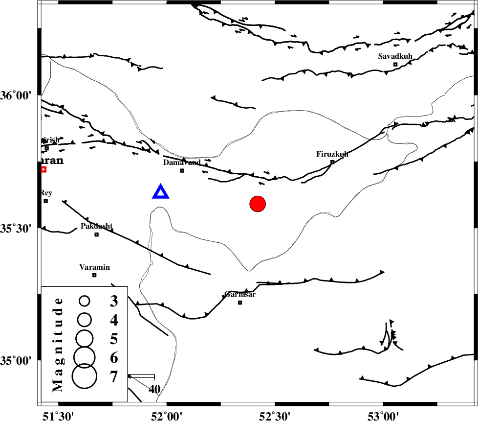
| Location | Lat:35.59 Lon: 52.42 |
| Region | Tehran Province, 42 km North of Garmsar |
Nearest Cities |
|
| 12 km East of Sarbandan, Tehran Province | |
| 17 km North West of Atashan, Tehran Province | |
| 24 km North East of Kilan, Tehran Province | |
| 25 km East of Mara, Tehran Province | |
| 26 km South West of Arjomand, Tehran Province | |
| Depth | 14 km |
| Agency | |
Faults within 150 km: |
|
| MOSHA_F (Length: 234 km) , Distance to epicenter: 12 km | |
| GARMSAR_F (Length: 77 km) , Distance to epicenter: 34 km | |
| EYVANEKEY_F (Length: 74 km) , Distance to epicenter: 35 km | |
| Number of Phases | 7 |
| RMS | 0.2 |
| Number of Stations | 7 |
| Error in Latitude | >4.4 km |
| Error in Longitude | 8.9 km |
| Error in Depth | 4.8 km |
Download waveform in seisan format
to download seisan software Click here
to access information about IIEES stations Click here
Amplitude | ||||||||
| UID | Agency | Station | Component | Amplitude | Period | Arrival Time | Proccessing Time | Signal Clip |
| 81823 | IIEES | CHTH | E | 5616.5 | 0.32 | 2012-02-10 09:00:19 | 2012-02-10 08:27:00 | n |
| 81824 | IIEES | THKV | E | 41429.5 | 0.48 | 2012-02-10 09:00:24 | 2012-02-10 08:27:00 | n |
| 81825 | IIEES | THKV | N | 21750.5 | 0.36 | 2012-02-10 09:00:25 | 2012-02-10 08:27:00 | n |
| 81826 | IIEES | ASAO | N | 2112.6 | 0.44 | 2012-02-10 09:00:51 | 2012-02-10 08:27:00 | n |
| 81827 | IIEES | ASAO | E | 2846.1 | 0.36 | 2012-02-10 09:00:51 | 2012-02-10 08:27:00 | n |
| 81828 | IIEES | KHMZ | N | 1330.2 | 0.4 | 2012-02-10 09:01:05 | 2012-02-10 08:27:00 | n |
Phase | ||||||||||||
| Agency | Station | Component | Phase Type | Phase Quality | First Motion | Observed Arrival Time | Time Residual | Loc. Flag | Input Weight | Distance | Azimuth | |
| IIEES | CHTH | Z | Pg | E | 2012-02-10 09:00:00 | -0.18 | y | 122 | 287 | |||
| IIEES | THKV | Z | Pg | E | 2012-02-10 09:00:04 | 0.11 | y | 144 | 285 | |||
| IIEES | GHVR | Z | Pg | E | 2012-02-10 09:00:06 | -0.09 | y | 163 | 221 | |||
| IIEES | ASAO | Z | Pn | E | 2012-02-10 09:00:18 | -0.19 | y | 247 | 243 | |||
| IIEES | KHMZ | Z | Pn | E | 2012-02-10 09:00:26 | 0.41 | y | 305 | 228 | |||
| IIEES | NASN | Z | Pn | E | 2012-02-10 09:00:26 | -0.11 | y | 312 | 173 | |||
| IIEES | ZNJK | Z | Pn | E | 2012-02-10 09:00:32 | 0.08 | y | 357 | 291 | |||