
Magnitude |
:2.9 |
| Date & Time (UTC) | 2012-02-09 12:01:18.3 |
| Date & Time (Local) | 1390/11/20 15:31:18.3 |
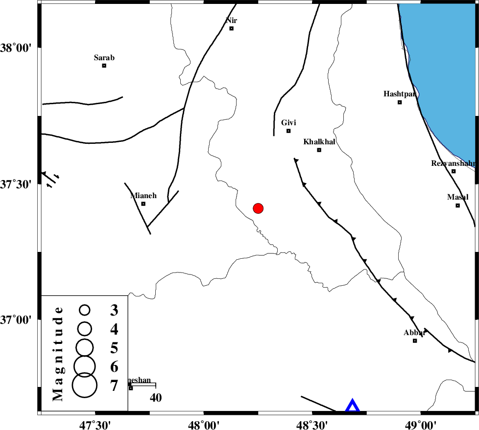
| Location | Lat:37.41 Lon: 48.25 |
| Region | Ardebil Province, 34 km South-West of Givi |
Nearest Cities |
|
| 8 km North of Hashtjin, Ardebil Province | |
| 20 km North East of Qareh belagh, Azarbaijan Sharghi Province | |
| 21 km South West of Gazaz, Ardebil Province | |
| 22 km South of Firuz Abad, Ardebil Province | |
| 24 km North East of Agkand, Azarbaijan Sharghi Province | |
| Depth | 14 km |
| Agency | |
Faults within 150 km: |
|
| MASULEL_F (Length: 90 km) , Distance to epicenter: 21 km | |
| SANGAVAR_F (Length: 61 km) , Distance to epicenter: 30 km | |
| BOZQUSH (Length: 70 km) , Distance to epicenter: 33 km | |
| Number of Phases | 7 |
| RMS | 0.2 |
| Number of Stations | 6 |
| Error in Latitude | >6.2 km |
| Error in Longitude | 8.5 km |
| Error in Depth | 9 km |
Download waveform in seisan format
to download seisan software Click here
to access information about IIEES stations Click here
Amplitude | ||||||||
| UID | Agency | Station | Component | Amplitude | Period | Arrival Time | Proccessing Time | Signal Clip |
| 81817 | IIEES | GRMI | E | 162.5 | 0.44 | 2012-02-09 12:02:09 | 2012-02-09 11:17:00 | n |
| 81818 | IIEES | GRMI | N | 168 | 0.38 | 2012-02-09 12:02:10 | 2012-02-09 11:17:00 | n |
Phase | ||||||||||||
| Agency | Station | Component | Phase Type | Phase Quality | First Motion | Observed Arrival Time | Time Residual | Loc. Flag | Input Weight | Distance | Azimuth | |
| IIEES | GRMI | Z | Pg | E | 2012-02-09 12:01:44 | -0.23 | y | 159 | 349 | |||
| IIEES | THKV | Z | Pn | E | 2012-02-09 12:02:02 | 0.31 | y | 287 | 124 | |||
| IIEES | THKV | N | Sg | E | 2012-02-09 12:02:39 | 0.02 | y | 287 | 124 | |||
| IIEES | CHTH | Z | Pn | E | 2012-02-09 12:02:04 | 0.03 | y | 306 | 122 | |||
| IIEES | ASAO | Z | Pn | E | 2012-02-09 12:02:10 | -0.11 | y | 355 | 153 | |||
| IIEES | MAKU | Z | P | E | 2012-02-09 12:02:13 | 0.32 | y | 379 | 306 | |||
| IIEES | KHMZ | Z | Pn | E | 2012-02-09 12:02:19 | -0.36 | y | 436 | 159 | |||