
Magnitude |
:3.2 |
| Date & Time (UTC) | 2012-02-02 10:51:11.6 |
| Date & Time (Local) | 1390/11/13 14:21:11.6 |
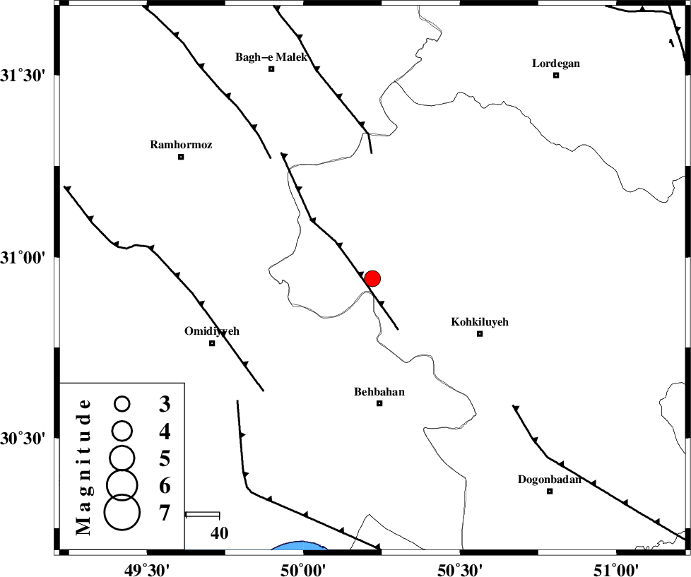
| Location | Lat:30.94 Lon: 50.22 |
| Region | Kohkiluieh va boyerahmad Province, 38 km North of Behbahan |
Nearest Cities |
|
| 20 km West of Lendeh, Kohkiluieh va boyerahmad Province | |
| 26 km North of Dodange-ye bozorg, Khoozestan Province | |
| 33 km North East of Jolaki, Khoozestan Province | |
| 35 km South West of Qale-ye raiesi, Kohkiluieh va boyerahmad Province | |
| 35 km North of Mansuriyeh, Khoozestan Province | |
| Depth | 15 km |
| Agency | |
Faults within 150 km: |
|
| MFF4 (Length: 62 km) , Distance to epicenter: 10 km | |
| MFF2 (Length: 205 km) , Distance to epicenter: 38 km | |
| AGHAJARI_F (Length: 88 km) , Distance to epicenter: 48 km | |
| Number of Phases | 8 |
| RMS | 0.6 |
| Number of Stations | 7 |
| Error in Latitude | >7.1 km |
| Error in Longitude | 18 km |
| Error in Depth | 26.3 km |
Download waveform in seisan format
to download seisan software Click here
to access information about IIEES stations Click here
Amplitude | ||||||||
| UID | Agency | Station | Component | Amplitude | Period | Arrival Time | Proccessing Time | Signal Clip |
| 81701 | IIEES | SHGR | E | 448.7 | 0.64 | 2012-02-02 10:52:13 | 2012-02-02 10:11:00 | n |
| 81702 | IIEES | SHGR | N | 243.2 | 0.28 | 2012-02-02 10:52:14 | 2012-02-02 10:11:00 | n |
| 81703 | IIEES | AHRM | N | 109 | 0.48 | 2012-02-02 10:52:39 | 2012-02-02 10:11:00 | n |
| 81704 | IIEES | GHIR | E | 33.2 | 0.6 | 2012-02-02 10:52:56 | 2012-02-02 10:11:00 | n |
Phase | ||||||||||||
| Agency | Station | Component | Phase Type | Phase Quality | First Motion | Observed Arrival Time | Time Residual | Loc. Flag | Input Weight | Distance | Azimuth | |
| IIEES | SHGR | Z | Pg | E | 2012-02-02 10:51:41 | -0.55 | y | 187 | 314 | |||
| IIEES | SHGR | E | Sg | E | 2012-02-02 10:52:04 | 0.23 | y | 187 | 314 | |||
| IIEES | AHRM | Z | Pn | E | 2012-02-02 10:51:51 | 0.78 | y | 252 | 155 | |||
| IIEES | KHMZ | Z | Pn | E | 2012-02-02 10:51:58 | 0.14 | y | 312 | 356 | |||
| IIEES | NASN | Z | Pn | E | 2012-02-02 10:51:59 | -0.17 | y | 321 | 49 | |||
| IIEES | GHIR | Z | Pn | E | 2012-02-02 10:52:07 | -0.92 | y | 398 | 137 | |||
| IIEES | ASAO | Z | Pn | E | 2012-02-02 10:52:08 | -0.4 | y | 401 | 357 | |||
| IIEES | GHVR | Z | Pn | E | 2012-02-02 10:52:10 | 0.8 | y | 405 | 14 | |||