
Magnitude |
:2.8 |
| Date & Time (UTC) | 2012-02-01 05:59:45.3 |
| Date & Time (Local) | 1390/11/12 09:29:45.3 |
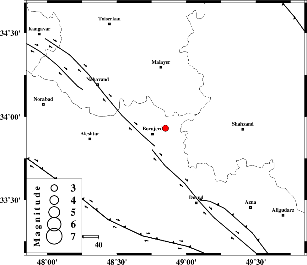
| Location | Lat:33.93 Lon: 48.85 |
| Region | Lorestan Province, 9 km Borujerd |
Nearest Cities |
|
| 8 km North of Valanjerd, Lorestan Province | |
| 9 km North of Borujerd, Lorestan Province | |
| 12 km North of Hemmatabad, Lorestan Province | |
| 17 km South of Mahdaviye, Hamedan Province | |
| 18 km East of Bon dizeh, Lorestan Province | |
| Depth | 14 km |
| Agency | |
Faults within 150 km: |
|
| NAHAVAND_F (Length: 102 km) , Distance to epicenter: 14 km | |
| DORUD (Length: 100 km) , Distance to epicenter: 17 km | |
| MAIN_ZAGROS_R_F (Length: 1106 km) , Distance to epicenter: 53 km | |
| Number of Phases | 6 |
| RMS | 0.1 |
| Number of Stations | 6 |
| Error in Latitude | >2.6 km |
| Error in Longitude | 5.7 km |
| Error in Depth | 5.5 km |
Download waveform in seisan format
to download seisan software Click here
to access information about IIEES stations Click here
Amplitude | ||||||||
| UID | Agency | Station | Component | Amplitude | Period | Arrival Time | Proccessing Time | Signal Clip |
| 81690 | IIEES | ASAO | E | 167.7 | 0.38 | 2012-02-01 06:00:29 | 2012-02-01 05:14:00 | n |
| 81691 | IIEES | SHGR | E | 90.2 | 0.59 | 2012-02-01 06:00:47 | 2012-02-01 05:14:00 | n |
| 81692 | IIEES | GHVR | E | 65.7 | 0.35 | 2012-02-01 06:00:58 | 2012-02-01 05:14:00 | n |
| 81693 | IIEES | THKV | E | 34.1 | 0.42 | 2012-02-01 06:01:12 | 2012-02-01 05:14:00 | n |
Phase | ||||||||||||
| Agency | Station | Component | Phase Type | Phase Quality | First Motion | Observed Arrival Time | Time Residual | Loc. Flag | Input Weight | Distance | Azimuth | |
| IIEES | KHMZ | Z | Pg | E | 2012-02-01 06:00:03 | 0.06 | y | 106 | 101 | |||
| IIEES | ASAO | Z | Pg | E | 2012-02-01 06:00:06 | -0.13 | y | 128 | 57 | |||
| IIEES | SHGR | Z | Pg | E | 2012-02-01 06:00:18 | -0.06 | y | 202 | 181 | |||
| IIEES | SHGR | E | Sg | E | 2012-02-01 06:00:42 | 0.03 | y | 202 | 181 | |||
| IIEES | THKV | Z | Pn | E | 2012-02-01 06:00:29 | 0.11 | y | 288 | 40 | |||
| IIEES | CHTH | Z | Pn | E | 2012-02-01 06:00:30 | 0.01 | y | 303 | 43 | |||