
Magnitude |
:3.1 |
| Date & Time (UTC) | 2012-01-25 19:38:22.1 |
| Date & Time (Local) | 1390/11/5 23:08:22.1 |
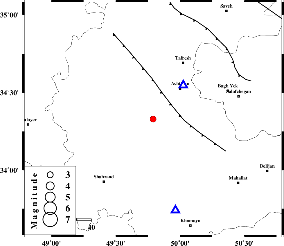
| Location | Lat:34.33 Lon: 49.79 |
| Region | Markazi Province, 28 km North-East of Arak |
Nearest Cities |
|
| 8 km North of Davoodabad, Markazi Province | |
| 11 km North of Ebakabad, Markazi Province | |
| 22 km South East of Farmahin, Markazi Province | |
| 26 km North East of Marzijaran, Markazi Province | |
| 27 km North West of Ebrahimabad, Markazi Province | |
| Depth | 14 km |
| Agency | |
Faults within 150 km: |
|
| TAFRESH_F (Length: 117 km) , Distance to epicenter: 17 km | |
| INDES_F (Length: 98 km) , Distance to epicenter: 69 km | |
| KUSHK_E_NOSRAT_F (Length: 230 km) , Distance to epicenter: 103 km | |
| Number of Phases | 7 |
| RMS | 0.1 |
| Number of Stations | 4 |
| Error in Latitude | >1.1 km |
| Error in Longitude | 2.4 km |
| Error in Depth | 3.2 km |
Download waveform in seisan format
to download seisan software Click here
to access information about IIEES stations Click here
Amplitude | ||||||||
| UID | Agency | Station | Component | Amplitude | Period | Arrival Time | Proccessing Time | Signal Clip |
| 81592 | IIEES | KHMZ | E | 1186.3 | 0.12 | 2012-01-25 19:38:42 | 2012-01-25 06:50:00 | n |
| 81593 | IIEES | KHMZ | N | 742.5 | 0.28 | 2012-01-25 19:38:43 | 2012-01-25 06:50:00 | n |
| 81594 | IIEES | GHVR | N | 245.3 | 0.36 | 2012-01-25 19:39:02 | 2012-01-25 06:50:00 | n |
| 81595 | IIEES | GHVR | E | 525.4 | 0.28 | 2012-01-25 19:39:02 | 2012-01-25 06:50:00 | n |
Phase | ||||||||||||
| Agency | Station | Component | Phase Type | Phase Quality | First Motion | Observed Arrival Time | Time Residual | Loc. Flag | Input Weight | Distance | Azimuth | |
| IIEES | ASAO | Z | Pg | E | 2012-01-25 19:38:28 | 0.04 | y | 32.8 | 41 | |||
| IIEES | ASAO | N | Sg | E | 2012-01-25 19:38:33 | -0.11 | y | 32.8 | 41 | |||
| IIEES | KHMZ | Z | Pg | E | 2012-01-25 19:38:33 | -0.09 | y | 67 | 166 | |||
| IIEES | GHVR | Z | Pg | E | 2012-01-25 19:38:44 | 0.02 | y | 135 | 82 | |||
| IIEES | GHVR | E | Sg | E | 2012-01-25 19:39:01 | 0.06 | y | 135 | 82 | |||
| IIEES | CHTH | Z | Pn | E | 2012-01-25 19:38:56 | 0.11 | y | 214 | 34 | |||
| IIEES | CHTH | E | Sg | E | 2012-01-25 19:39:22 | -0.04 | y | 214 | 34 | |||