
Magnitude |
:3.3 |
| Date & Time (UTC) | 2012-01-25 17:59:45.0 |
| Date & Time (Local) | 1390/11/5 21:29:45.0 |
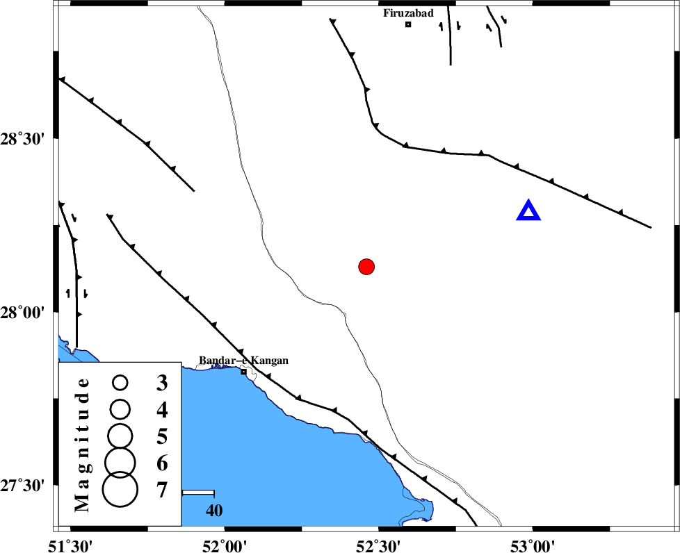
| Location | Lat:28.13 Lon: 52.46 |
| Region | Fars Province, 36 km North-East of Jam |
Nearest Cities |
|
| 17 km East of Dolatabad, Fars Province | |
| 30 km North West of Garmesht, Fars Province | |
| 32 km South West of Hengam, Fars Province | |
| 36 km North East of Jam, Bushehr Province | |
| 39 km North East of Riz, Bushehr Province | |
| Depth | 14 km |
| Agency | |
Faults within 150 km: |
|
| QIR_F (Length: 130 km) , Distance to epicenter: 40 km | |
| MFF3 (Length: 292 km) , Distance to epicenter: 47 km | |
| MFF5 (Length: 74 km) , Distance to epicenter: 60 km | |
| Number of Phases | 6 |
| RMS | 0.1 |
| Number of Stations | 4 |
| Error in Latitude | >5.3 km |
| Error in Longitude | 1.4 km |
| Error in Depth | 5.3 km |
Download waveform in seisan format
to download seisan software Click here
to access information about IIEES stations Click here
Amplitude | ||||||||
| UID | Agency | Station | Component | Amplitude | Period | Arrival Time | Proccessing Time | Signal Clip |
| 81588 | IIEES | GHIR | N | 2638.4 | 0.4 | 2012-01-25 18:00:10 | 2012-01-25 05:10:00 | n |
| 81589 | IIEES | GHIR | E | 2753.5 | 0.4 | 2012-01-25 18:00:12 | 2012-01-25 05:10:00 | n |
| 81590 | IIEES | AHRM | E | 438 | 0.44 | 2012-01-25 18:00:27 | 2012-01-25 05:10:00 | n |
| 81591 | IIEES | AHRM | N | 521.1 | 0.48 | 2012-01-25 18:00:27 | 2012-01-25 05:10:00 | n |
Phase | ||||||||||||
| Agency | Station | Component | Phase Type | Phase Quality | First Motion | Observed Arrival Time | Time Residual | Loc. Flag | Input Weight | Distance | Azimuth | |
| IIEES | GHIR | Z | Pg | E | 2012-01-25 17:59:54 | -0.15 | y | 54.7 | 71 | |||
| IIEES | GHIR | N | Sg | E | 2012-01-25 18:00:02 | 0.04 | y | 54.7 | 71 | |||
| IIEES | AHRM | Z | Pg | E | 2012-01-25 18:00:08 | -0.12 | y | 140 | 306 | |||
| IIEES | AHRM | N | Sg | E | 2012-01-25 18:00:25 | 0.09 | y | 140 | 306 | |||
| IIEES | BNDS | Z | Pn | E | 2012-01-25 18:00:39 | 0.11 | y | 375 | 102 | |||
| IIEES | KRBR | Z | Pn | E | 2012-01-25 18:00:50 | 0.07 | y | 467 | 63 | |||