
Magnitude |
:2.6 |
| Date & Time (UTC) | 2012-01-25 10:19:03.0 |
| Date & Time (Local) | 1390/11/5 13:49:03.0 |
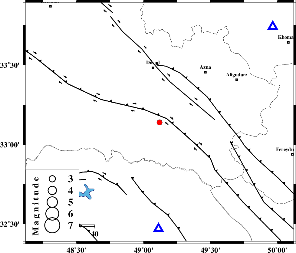
| Location | Lat:33.14 Lon: 49.12 |
| Region | Lorestan Province, 38 km South of Dorud |
Nearest Cities |
|
| 7 km of Shulabad, Lorestan Province | |
| 20 km North East of Bargsar, Lorestan Province | |
| 21 km South East of Sartang barzeh, Lorestan Province | |
| 29 km East of Chamsangar, Lorestan Province | |
| 35 km South of Heshmatabad, Lorestan Province | |
| Depth | 6 km |
| Agency | |
Faults within 150 km: |
|
| HZF4 (Length: 492 km) , Distance to epicenter: 6 km | |
| DORUD (Length: 100 km) , Distance to epicenter: 29 km | |
| MAIN_ZAGROS_R_F (Length: 1106 km) , Distance to epicenter: 37 km | |
| Number of Phases | 5 |
| RMS | 0.2 |
| Number of Stations | 5 |
| Error in Latitude | >3.7 km |
| Error in Longitude | 8.4 km |
| Error in Depth | 5.5 km |
Download waveform in seisan format
to download seisan software Click here
to access information about IIEES stations Click here
Amplitude | ||||||||
| UID | Agency | Station | Component | Amplitude | Period | Arrival Time | Proccessing Time | Signal Clip |
| 81576 | IIEES | SHGR | N | 186.8 | 0.63 | 2012-01-25 10:19:41 | 2012-01-25 10:41:00 | n |
| 81577 | IIEES | ASAO | E | 65.7 | 0.58 | 2012-01-25 10:20:02 | 2012-01-25 10:41:00 | n |
Phase | ||||||||||||
| Agency | Station | Component | Phase Type | Phase Quality | First Motion | Observed Arrival Time | Time Residual | Loc. Flag | Input Weight | Distance | Azimuth | |
| IIEES | KHMZ | Z | Pg | E | 2012-01-25 10:19:20 | -0.25 | y | 103 | 50 | |||
| IIEES | SHGR | Z | Pg | E | 2012-01-25 10:19:23 | -0.09 | y | 118 | 195 | |||
| IIEES | ASAO | Z | Pg | E | 2012-01-25 10:19:33 | -0.13 | y | 177 | 28 | |||
| IIEES | NASN | Z | Pn | E | 2012-01-25 10:19:55 | 0.18 | y | 347 | 95 | |||
| IIEES | CHTH | Z | Pn | E | 2012-01-25 10:19:56 | 0.38 | y | 358 | 30 | |||