
Magnitude |
:3.7 |
| Date & Time (UTC) | 2012-01-22 03:22:20.2 |
| Date & Time (Local) | 1390/11/2 06:52:20.2 |
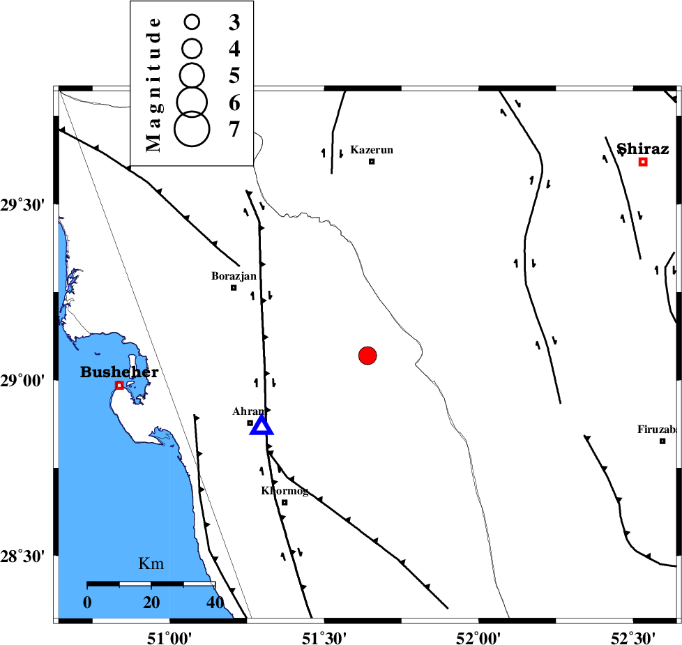
| Location | Lat:29.07 Lon: 51.64 |
| Region | Bushehr Province, 61 km South of Kazerun |
Nearest Cities |
|
| 23 km North East of Kalameh, Bushehr Province | |
| 35 km South West of Dadin-e olia, Fars Province | |
| 35 km West of Nujin, Fars Province | |
| 37 km South West of Baladeh, Fars Province | |
| 38 km South West of Jareh, Fars Province | |
| Depth | 29 km |
| Agency | |
Faults within 150 km: |
|
| BORAZJAN_F (Length: 168 km) , Distance to epicenter: 32 km | |
| MFF5 (Length: 74 km) , Distance to epicenter: 44 km | |
| ZFF3 (Length: 125 km) , Distance to epicenter: 49 km | |
| Number of Phases | 5 |
| RMS | 0.2 |
| Number of Stations | 3 |
| Error in Latitude | >5.9 km |
| Error in Longitude | 4 km |
| Error in Depth | 7.4 km |
Download waveform in seisan format
to download seisan software Click here
to access information about IIEES stations Click here
Amplitude | ||||||||
| UID | Agency | Station | Component | Amplitude | Period | Arrival Time | Proccessing Time | Signal Clip |
| 81529 | IIEES | AHRM | E | 4412.8 | 0.44 | 2012-01-22 03:22:39 | 2012-01-22 02:38:00 | n |
| 81530 | IIEES | AHRM | N | 4796.8 | 0.6 | 2012-01-22 03:22:42 | 2012-01-22 02:38:00 | n |
| 81531 | IIEES | GHIR | E | 2542.8 | 0.88 | 2012-01-22 03:23:14 | 2012-01-22 02:38:00 | n |
| 81532 | IIEES | GHIR | N | 836.2 | 0.56 | 2012-01-22 03:23:15 | 2012-01-22 02:38:00 | n |
Phase | ||||||||||||
| Agency | Station | Component | Phase Type | Phase Quality | First Motion | Observed Arrival Time | Time Residual | Loc. Flag | Input Weight | Distance | Azimuth | |
| IIEES | AHRM | Z | Pg | E | 2012-01-22 03:22:28 | 0.4 | y | 40.7 | 235 | |||
| IIEES | AHRM | E | Sg | E | 2012-01-22 03:22:34 | -0.28 | y | 40.7 | 235 | |||
| IIEES | GHIR | Z | Pn | E | 2012-01-22 03:22:46 | 0 | y | 158 | 123 | |||
| IIEES | GHIR | N | Sg | E | 2012-01-22 03:23:04 | -0.03 | y | 158 | 123 | |||
| IIEES | NASN | Z | Pn | E | 2012-01-22 03:23:19 | -0.12 | y | 428 | 15 | |||