
Magnitude |
:3.9 |
| Date & Time (UTC) | 2012-01-16 15:06:34.2 |
| Date & Time (Local) | 1390/10/26 18:36:34.2 |
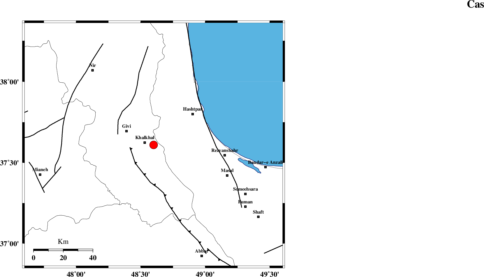
| Location | Lat:37.61 Lon: 48.6 |
| Region | Ardebil Province, 6 km Khalkhal |
Nearest Cities |
|
| 4 km North of Khojin, Ardebil Province | |
| 6 km of Khalkhal, Ardebil Province | |
| 20 km North East of Gazaz, Ardebil Province | |
| 21 km East of Givi, Ardebil Province | |
| 26 km North West of Ardeh, Gilan Province | |
| Depth | 14 km |
| Agency | |
Faults within 150 km: |
|
| MASULEL_F (Length: 90 km) , Distance to epicenter: 16 km | |
| SANGAVAR_F (Length: 61 km) , Distance to epicenter: 26 km | |
| TALESH_F (Length: 258 km) , Distance to epicenter: 39 km | |
| Number of Phases | 7 |
| RMS | 0.1 |
| Number of Stations | 6 |
| Error in Latitude | >1.9 km |
| Error in Longitude | 8.6 km |
| Error in Depth | 6.6 km |
Download waveform in seisan format
to download seisan software Click here
to access information about IIEES stations Click here
Amplitude | ||||||||
| UID | Agency | Station | Component | Amplitude | Period | Arrival Time | Proccessing Time | Signal Clip |
| 81382 | IIEES | THKV | E | 433 | 0.36 | 2012-01-16 15:07:52 | 2012-01-16 02:27:00 | n |
| 81383 | IIEES | THKV | N | 725.9 | 0.44 | 2012-01-16 15:07:53 | 2012-01-16 02:27:00 | n |
Phase | ||||||||||||
| Agency | Station | Component | Phase Type | Phase Quality | First Motion | Observed Arrival Time | Time Residual | Loc. Flag | Input Weight | Distance | Azimuth | |
| IIEES | ZNJK | Z | Pg | E | 2012-01-16 15:06:52 | -0.03 | y | 105 | 176 | |||
| IIEES | ZNJK | E | Sg | E | 2012-01-16 15:07:05 | 0.01 | y | 105 | 176 | |||
| IIEES | GRMI | Z | Pg | E | 2012-01-16 15:06:58 | 0.06 | y | 146 | 335 | |||
| IIEES | GRMI | N | Sg | E | 2012-01-16 15:07:16 | -0.04 | y | 146 | 335 | |||
| IIEES | CHTH | Z | Pn | E | 2012-01-16 15:07:18 | -0.11 | y | 294 | 129 | |||
| IIEES | ASAO | Z | Pn | E | 2012-01-16 15:07:27 | 0.04 | y | 364 | 159 | |||
| IIEES | GHVR | Z | Pn | E | 2012-01-16 15:07:34 | 0.1 | y | 421 | 145 | |||