
Magnitude |
:3.2 |
| Date & Time (UTC) | 2012-01-14 22:36:41.8 |
| Date & Time (Local) | 1390/10/25 02:06:41.8 |
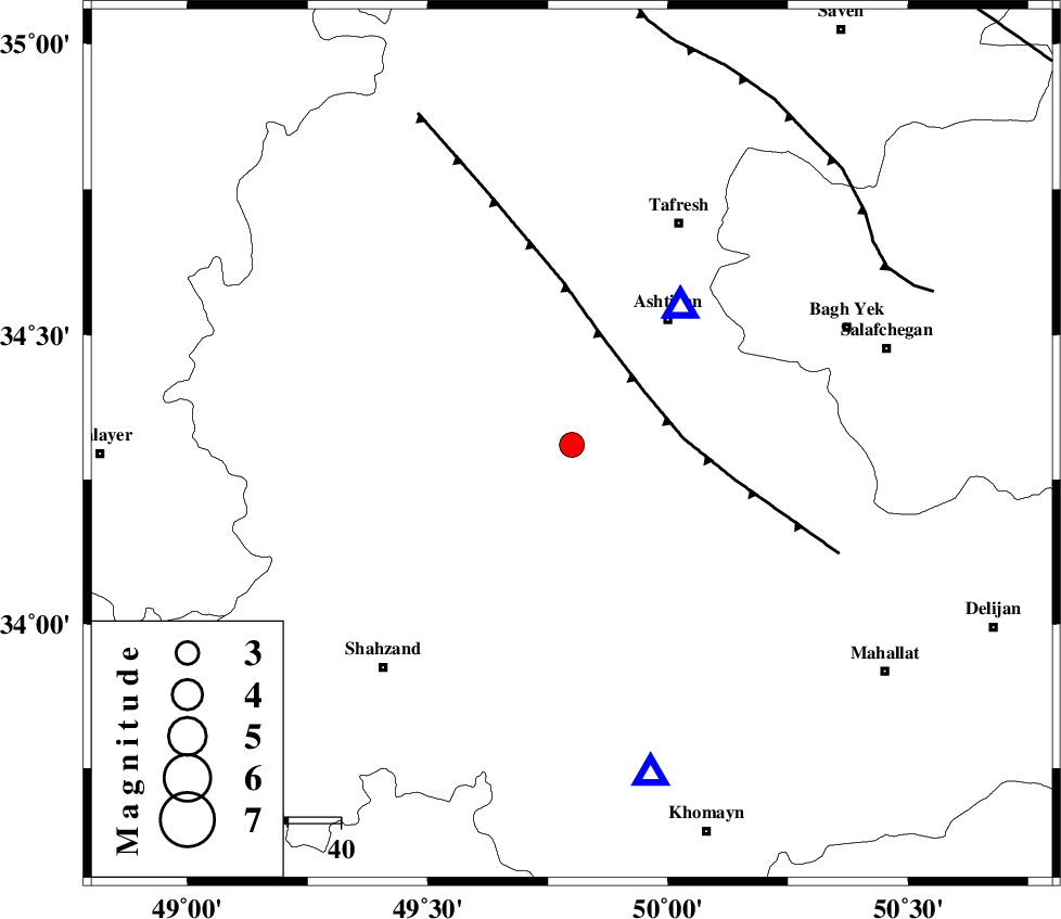
| Location | Lat:34.31 Lon: 49.8 |
| Region | Markazi Province, 27 km North-East of Arak |
Nearest Cities |
|
| 7 km North of Davoodabad, Markazi Province | |
| 11 km North of Ebakabad, Markazi Province | |
| 24 km North East of Marzijaran, Markazi Province | |
| 25 km South East of Farmahin, Markazi Province | |
| 25 km North West of Ebrahimabad, Markazi Province | |
| Depth | 14 km |
| Agency | |
Faults within 150 km: |
|
| TAFRESH_F (Length: 117 km) , Distance to epicenter: 17 km | |
| INDES_F (Length: 98 km) , Distance to epicenter: 69 km | |
| KUSHK_E_NOSRAT_F (Length: 230 km) , Distance to epicenter: 105 km | |
| Number of Phases | 6 |
| RMS | 0.1 |
| Number of Stations | 5 |
| Error in Latitude | >1 km |
| Error in Longitude | 5.1 km |
| Error in Depth | 3.6 km |
Download waveform in seisan format
to download seisan software Click here
to access information about IIEES stations Click here
Amplitude | ||||||||
| UID | Agency | Station | Component | Amplitude | Period | Arrival Time | Proccessing Time | Signal Clip |
| 81363 | IIEES | ASAO | N | 2522.8 | 0.24 | 2012-01-14 22:36:52 | 2012-01-14 10:05:00 | n |
| 81364 | IIEES | ASAO | E | 4189.1 | 0.2 | 2012-01-14 22:36:53 | 2012-01-14 10:05:00 | n |
| 81365 | IIEES | KHMZ | E | 1223 | 0.16 | 2012-01-14 22:37:02 | 2012-01-14 10:05:00 | n |
| 81366 | IIEES | KHMZ | N | 910.6 | 0.16 | 2012-01-14 22:37:03 | 2012-01-14 10:05:00 | n |
| 81367 | IIEES | GHVR | E | 484.7 | 0.2 | 2012-01-14 22:37:22 | 2012-01-14 10:05:00 | n |
| 81368 | IIEES | GHVR | N | 516 | 0.76 | 2012-01-14 22:37:22 | 2012-01-14 10:05:00 | n |
| 81369 | IIEES | THKV | N | 147 | 0.16 | 2012-01-14 22:37:43 | 2012-01-14 10:05:00 | n |
Phase | ||||||||||||
| Agency | Station | Component | Phase Type | Phase Quality | First Motion | Observed Arrival Time | Time Residual | Loc. Flag | Input Weight | Distance | Azimuth | |
| IIEES | ASAO | Z | Pg | E | 2012-01-14 22:36:48 | -0.07 | y | 33.5 | 38 | |||
| IIEES | KHMZ | Z | Pg | E | 2012-01-14 22:36:53 | 0.12 | y | 64.9 | 167 | |||
| IIEES | KHMZ | N | Sg | E | 2012-01-14 22:37:01 | -0.1 | y | 64.9 | 167 | |||
| IIEES | GHVR | Z | Pg | E | 2012-01-14 22:37:04 | 0.06 | y | 134 | 81 | |||
| IIEES | THKV | Z | Pg | E | 2012-01-14 22:37:15 | 0.02 | y | 204 | 29 | |||
| IIEES | CHTH | Z | Pn | E | 2012-01-14 22:37:16 | -0.03 | y | 215 | 34 | |||