
Magnitude |
:2.8 |
| Date & Time (UTC) | 2012-01-14 09:45:11.9 |
| Date & Time (Local) | 1390/10/24 13:15:11.9 |
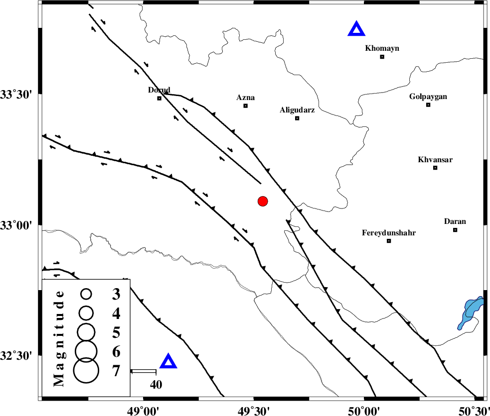
| Location | Lat:33.09 Lon: 49.54 |
| Region | Lorestan Province, 41 km South of Azna |
Nearest Cities |
|
| 21 km North of Parchal, Lorestan Province | |
| 24 km South West of Shapoorabad, Lorestan Province | |
| 24 km South West of Shapoorabad, Lorestan Province | |
| 31 km North West of Farsesh, Lorestan Province | |
| 35 km South of Sur, Lorestan Province | |
| Depth | 15 km |
| Agency | |
Faults within 150 km: |
|
| DORUD (Length: 100 km) , Distance to epicenter: 7 km | |
| MAIN_ZAGROS_R_F (Length: 1106 km) , Distance to epicenter: 11 km | |
| ARDAL_F (Length: 170 km) , Distance to epicenter: 13 km | |
| Number of Phases | 7 |
| RMS | 0 |
| Number of Stations | 5 |
| Error in Latitude | >0.9 km |
| Error in Longitude | 1.3 km |
| Error in Depth | 2.4 km |
Download waveform in seisan format
to download seisan software Click here
to access information about IIEES stations Click here
Amplitude | ||||||||
| UID | Agency | Station | Component | Amplitude | Period | Arrival Time | Proccessing Time | Signal Clip |
| 81351 | IIEES | KHMZ | E | 425.4 | 0.56 | 2012-01-14 09:45:40 | 2012-01-14 09:13:00 | n |
| 81352 | IIEES | SHGR | N | 225.4 | 0.72 | 2012-01-14 09:45:54 | 2012-01-14 09:13:00 | n |
| 81353 | IIEES | SHGR | E | 196.7 | 0.56 | 2012-01-14 09:45:58 | 2012-01-14 09:13:00 | n |
| 81354 | IIEES | ASAO | N | 83.7 | 0.56 | 2012-01-14 09:46:10 | 2012-01-14 09:13:00 | n |
| 81355 | IIEES | GHVR | E | 56.3 | 0.64 | 2012-01-14 09:46:30 | 2012-01-14 09:13:00 | n |
Phase | ||||||||||||
| Agency | Station | Component | Phase Type | Phase Quality | First Motion | Observed Arrival Time | Time Residual | Loc. Flag | Input Weight | Distance | Azimuth | |
| IIEES | KHMZ | Z | Pg | E | 2012-01-14 09:45:26 | -0.01 | y | 82.6 | 29 | |||
| IIEES | KHMZ | E | Sg | E | 2012-01-14 09:45:36 | 0.04 | y | 82.6 | 29 | |||
| IIEES | SHGR | Z | Pg | E | 2012-01-14 09:45:33 | 0.01 | y | 129 | 213 | |||
| IIEES | ASAO | Z | Pg | E | 2012-01-14 09:45:39 | -0.03 | y | 168 | 15 | |||
| IIEES | GHVR | Z | Pn | E | 2012-01-14 09:45:47 | -0.02 | y | 221 | 45 | |||
| IIEES | NASN | Z | Pn | E | 2012-01-14 09:45:58 | 0.02 | y | 308 | 95 | |||
| IIEES | NASN | E | Sg | E | 2012-01-14 09:46:38 | -0.01 | y | 308 | 95 | |||