
Magnitude |
:3.6 |
| Date & Time (UTC) | 2012-01-03 00:56:30.8 |
| Date & Time (Local) | 1390/10/13 04:26:30.8 |
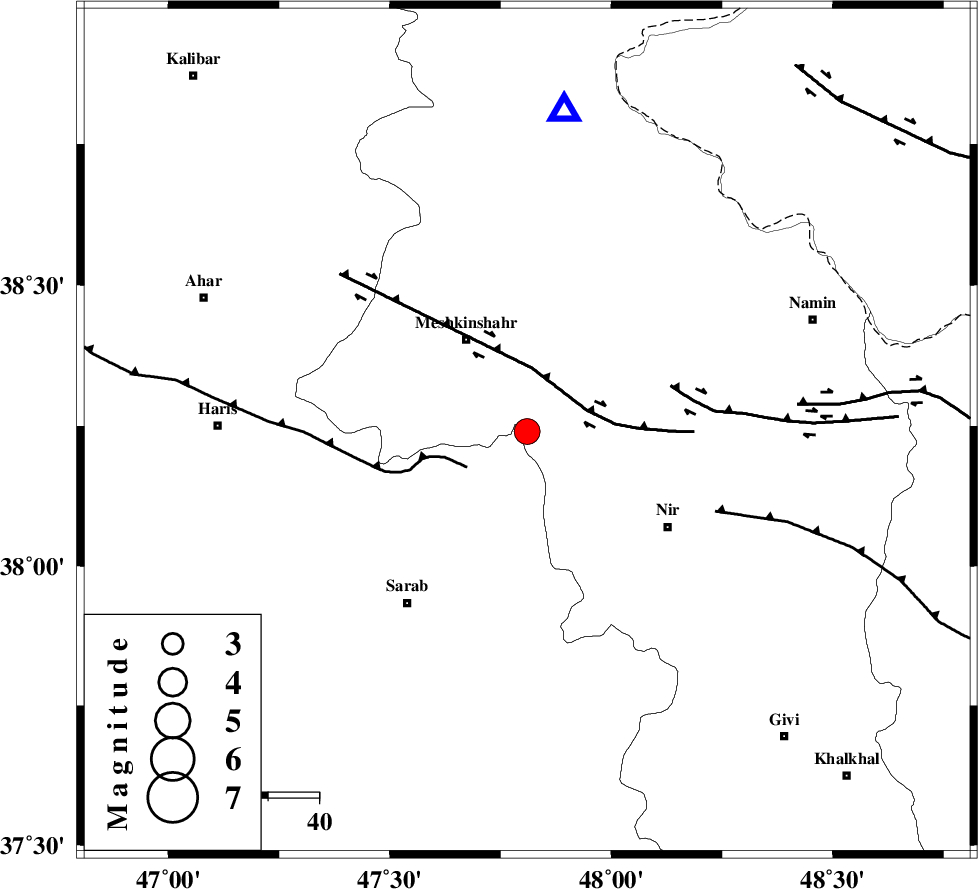
| Location | Lat:38.24 Lon: 47.81 |
| Region | Ardebil Province, 22 km South-East of Meshgin Shahr |
Nearest Cities |
|
| 11 km of Manueil, Ardebil Province | |
| 22 km South East of Meshgin Shahr, Ardebil Province | |
| 24 km North West of Eslamabad, Ardebil Province | |
| 24 km South of Aali, Ardebil Province | |
| 26 km North of Kalian, Azarbaijan Sharghi Province | |
| Depth | 14 km |
| Agency | |
Faults within 150 km: |
|
| BOZQUSH (Length: 70 km) , Distance to epicenter: 34 km | |
| SANGAVAR_F (Length: 61 km) , Distance to epicenter: 63 km | |
| MASULEL_F (Length: 90 km) , Distance to epicenter: 89 km | |
| Number of Phases | 9 |
| RMS | 0.2 |
| Number of Stations | 7 |
| Error in Latitude | >3.3 km |
| Error in Longitude | 2.7 km |
| Error in Depth | 9.7 km |
Download waveform in seisan format
to download seisan software Click here
to access information about IIEES stations Click here
Amplitude | ||||||||
| UID | Agency | Station | Component | Amplitude | Period | Arrival Time | Proccessing Time | Signal Clip |
| 81230 | IIEES | THKV | E | 126.4 | 0.44 | 2012-01-03 00:58:10 | 2012-01-03 12:24:00 | n |
Phase | ||||||||||||
| Agency | Station | Component | Phase Type | Phase Quality | First Motion | Observed Arrival Time | Time Residual | Loc. Flag | Input Weight | Distance | Azimuth | |
| IIEES | GRMI | Z | Pg | E | 2012-01-03 00:56:41 | -0.19 | y | 63.5 | 6 | |||
| IIEES | GRMI | E | Sg | E | 2012-01-03 00:56:50 | 0.1 | y | 63.5 | 6 | |||
| IIEES | MAKU | Z | Pn | E | 2012-01-03 00:57:16 | 0.32 | y | 299 | 295 | |||
| IIEES | MAKU | E | Sg | E | 2012-01-03 00:57:54 | -0.1 | y | 299 | 295 | |||
| IIEES | SNGE | Z | Pn | E | 2012-01-03 00:57:22 | 0 | y | 352 | 187 | |||
| IIEES | THKV | Z | Pn | E | 2012-01-03 00:57:25 | 0.24 | y | 375 | 132 | |||
| IIEES | CHTH | Z | Pn | E | 2012-01-03 00:57:27 | 0.1 | y | 392 | 130 | |||
| IIEES | ASAO | Z | Pn | E | 2012-01-03 00:57:34 | -0.48 | y | 455 | 153 | |||
| IIEES | KHMZ | Z | Pn | E | 2012-01-03 00:57:45 | -0.08 | y | 536 | 158 | |||