
Magnitude |
:3.8 |
| Date & Time (UTC) | 2011-12-28 11:58:35.8 |
| Date & Time (Local) | 1390/10/7 15:28:35.8 |
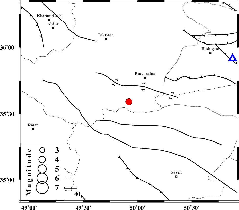
| Location | Lat:35.59 Lon: 49.92 |
| Region | Ghazvin Province, 24 km South-West of Buinzara |
Nearest Cities |
|
| 20 km South of Sagezabad, Ghazvin Province | |
| 23 km North of Duzaj, Markazi Province | |
| 24 km South West of Buinzara, Ghazvin Province | |
| 27 km South East of Danesfahan, Ghazvin Province | |
| 29 km North of Razegian, Markazi Province | |
| Depth | 15 km |
| Agency | |
Faults within 150 km: |
|
| IPAK_F (Length: 80 km) , Distance to epicenter: 14 km | |
| S_PARANDAK_F (Length: 116 km) , Distance to epicenter: 20 km | |
| KUSHK_E_NOSRAT_F (Length: 230 km) , Distance to epicenter: 33 km | |
| Number of Phases | 7 |
| RMS | 0.4 |
| Number of Stations | 8 |
| Error in Latitude | >3.9 km |
| Error in Longitude | 5.1 km |
| Error in Depth | 8 km |
Download waveform in seisan format
to download seisan software Click here
to access information about IIEES stations Click here
Amplitude | ||||||||
| UID | Agency | Station | Component | Amplitude | Period | Arrival Time | Proccessing Time | Signal Clip |
| 81163 | IIEES | GHVR | N | 1159 | 0.52 | 2011-12-28 11:59:30 | 2011-12-28 11:26:00 | n |
| 81164 | IIEES | GHVR | E | 2599.5 | 0.37 | 2011-12-28 11:59:31 | 2011-12-28 11:26:00 | n |
| 81165 | IIEES | SNGE | N | 382 | 0.52 | 2011-12-28 11:59:45 | 2011-12-28 11:26:00 | n |
| 81166 | IIEES | NASN | E | 161.6 | 0.43 | 2011-12-28 12:00:28 | 2011-12-28 11:26:00 | n |
| 81167 | IIEES | NASN | N | 149.9 | 0.36 | 2011-12-28 12:00:28 | 2011-12-28 11:26:00 | n |
Phase | ||||||||||||
| Agency | Station | Component | Phase Type | Phase Quality | First Motion | Observed Arrival Time | Time Residual | Loc. Flag | Input Weight | Distance | Azimuth | |
| IIEES | THKV | Z | Pg | E | 2011-12-28 11:58:52 | 0.31 | y | 94.3 | 67 | |||
| IIEES | CHTH | Z | Pg | E | 2011-12-28 11:58:55 | -0.05 | y | 115 | 72 | |||
| IIEES | ASAO | Z | Pg | E | 2011-12-28 11:58:55 | -0.2 | y | 116 | 175 | |||
| IIEES | ZNJK | Z | Pg | E | 2011-12-28 11:59:02 | -0.55 | y | 163 | 318 | |||
| IIEES | GHVR | Z | Pg | E | 2011-12-28 11:59:04 | 0.05 | y | 173 | 135 | |||
| IIEES | KHMZ | Z | Pn | E | 2011-12-28 11:59:08 | -0.35 | y | 205 | 179 | |||
| IIEES | SNGE | Z | Pn | E | 2011-12-28 11:59:14 | 0.8 | y | 240 | 257 | |||