
Magnitude |
:3.3 |
| Date & Time (UTC) | 2011-12-25 08:56:46.1 |
| Date & Time (Local) | 1390/10/4 12:26:46.1 |
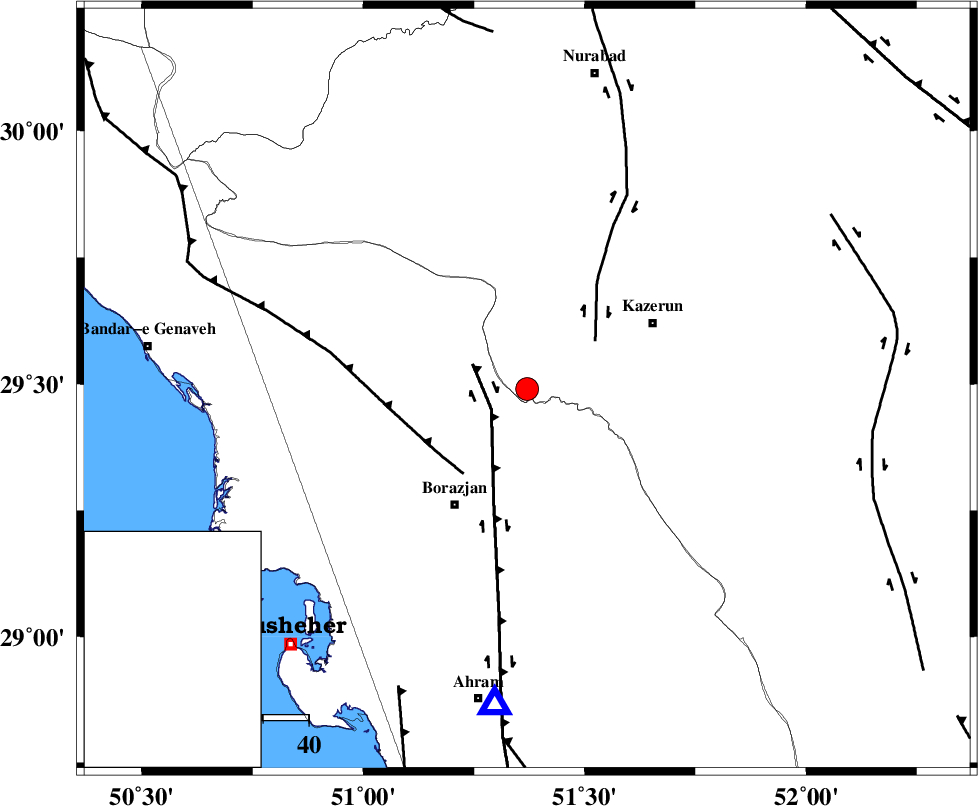
| Location | Lat:29.49 Lon: 51.37 |
| Region | Fars Province, 30 km North-East of Borazjan |
Nearest Cities |
|
| 9 km of Khesht, Fars Province | |
| 10 km North of Dalki, Bushehr Province | |
| 19 km South West of Kamaraj, Fars Province | |
| 22 km North East of Nazar aqa, Bushehr Province | |
| 27 km North East of Saedabad, Bushehr Province | |
| Depth | 35 km |
| Agency | |
Faults within 150 km: |
|
| BORAZJAN_F (Length: 168 km) , Distance to epicenter: 9 km | |
| KAZERUN_F (Length: 96 km) , Distance to epicenter: 18 km | |
| ZFF3 (Length: 125 km) , Distance to epicenter: 23 km | |
| Number of Phases | 6 |
| RMS | 0.2 |
| Number of Stations | 5 |
| Error in Latitude | >4 km |
| Error in Longitude | 3.7 km |
| Error in Depth | 5.7 km |
Download waveform in seisan format
to download seisan software Click here
to access information about IIEES stations Click here
Amplitude | ||||||||
| UID | Agency | Station | Component | Amplitude | Period | Arrival Time | Proccessing Time | Signal Clip |
| 81106 | IIEES | AHRM | E | 892 | 0.48 | 2011-12-25 08:57:19 | 2011-12-25 08:17:00 | n |
| 81107 | IIEES | AHRM | N | 834.3 | 0.54 | 2011-12-25 08:57:20 | 2011-12-25 08:17:00 | n |
| 81108 | IIEES | GHIR | N | 302.5 | 0.42 | 2011-12-25 08:57:53 | 2011-12-25 08:17:00 | n |
| 81109 | IIEES | GHIR | E | 329.7 | 0.55 | 2011-12-25 08:57:58 | 2011-12-25 08:17:00 | n |
| 81110 | IIEES | SHGR | N | 116 | 0.63 | 2011-12-25 08:58:56 | 2011-12-25 08:17:00 | n |
| 81111 | IIEES | KHMZ | E | 16.2 | 0.63 | 2011-12-25 08:59:09 | 2011-12-25 08:17:00 | n |
Phase | ||||||||||||
| Agency | Station | Component | Phase Type | Phase Quality | First Motion | Observed Arrival Time | Time Residual | Loc. Flag | Input Weight | Distance | Azimuth | |
| IIEES | AHRM | Z | Pg | E | 2011-12-25 08:56:58 | -0.05 | y | 69.8 | 186 | |||
| IIEES | GHIR | Z | Pn | E | 2011-12-25 08:57:17 | -0.05 | y | 207 | 130 | |||
| IIEES | GHIR | N | Sg | E | 2011-12-25 08:57:43 | 0.06 | y | 207 | 130 | |||
| IIEES | SHGR | Z | Pn | E | 2011-12-25 08:57:39 | 0.23 | y | 380 | 320 | |||
| IIEES | KHMZ | Z | Pn | E | 2011-12-25 08:57:52 | -0.29 | y | 490 | 345 | |||
| IIEES | GHVR | Z | Pn | E | 2011-12-25 08:58:00 | 0.08 | y | 553 | 359 | |||