
Magnitude |
:2.8 |
| Date & Time (UTC) | 2011-12-21 21:27:57.0 |
| Date & Time (Local) | 1390/10/1 00:57:57.0 |
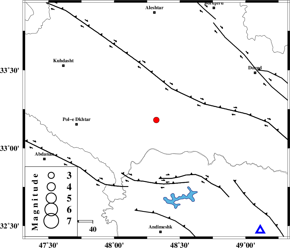
| Location | Lat:33.18 Lon: 48.32 |
| Region | Lorestan Province, 34 km South of Khorramabad |
Nearest Cities |
|
| 23 km South of Daraei, Lorestan Province | |
| 26 km South East of Shoorab-e sofla, Lorestan Province | |
| 30 km South of Badrabad-e sofla, Lorestan Province | |
| 33 km South West of Kamalvand-e gholamali, Lorestan Province | |
| 34 km South of Khorramabad, Lorestan Province | |
| Depth | 14 km |
| Agency | |
Faults within 150 km: |
|
| HZF4 (Length: 492 km) , Distance to epicenter: 25 km | |
| BALARUD_F_Z2 (Length: 58 km) , Distance to epicenter: 42 km | |
| BALARUD_F_Z3 (Length: 53 km) , Distance to epicenter: 45 km | |
| Number of Phases | 6 |
| RMS | 0.1 |
| Number of Stations | 4 |
| Error in Latitude | >1.7 km |
| Error in Longitude | 3.4 km |
| Error in Depth | 6.5 km |
Download waveform in seisan format
to download seisan software Click here
to access information about IIEES stations Click here
Amplitude | ||||||||
| UID | Agency | Station | Component | Amplitude | Period | Arrival Time | Proccessing Time | Signal Clip |
| 81073 | IIEES | SHGR | N | 184.2 | 0.32 | 2011-12-21 21:28:39 | 2011-12-21 08:50:00 | n |
| 81074 | IIEES | SHGR | E | 245.7 | 0.28 | 2011-12-21 21:28:40 | 2011-12-21 08:50:00 | n |
| 81075 | IIEES | ASAO | N | 75 | 0.6 | 2011-12-21 21:29:03 | 2011-12-21 08:50:00 | n |
Phase | ||||||||||||
| Agency | Station | Component | Phase Type | Phase Quality | First Motion | Observed Arrival Time | Time Residual | Loc. Flag | Input Weight | Distance | Azimuth | |
| IIEES | SHGR | Z | Pg | E | 2011-12-21 21:28:18 | -0.19 | y | 127 | 159 | |||
| IIEES | SHGR | E | Sg | E | 2011-12-21 21:28:33 | 0.13 | y | 127 | 159 | |||
| IIEES | KHMZ | Z | Pg | E | 2011-12-21 21:28:24 | 0.06 | y | 165 | 68 | |||
| IIEES | KHMZ | N | Sg | E | 2011-12-21 21:28:44 | -0.02 | y | 165 | 68 | |||
| IIEES | ASAO | Z | Pn | E | 2011-12-21 21:28:32 | -0.03 | y | 219 | 46 | |||
| IIEES | SNGE | Z | P | E | 2011-12-21 21:28:33 | 0.05 | y | 230 | 337 | |||