
Magnitude |
:3.4 |
| Date & Time (UTC) | 2011-12-17 23:25:35.8 |
| Date & Time (Local) | 1390/9/27 02:55:35.8 |
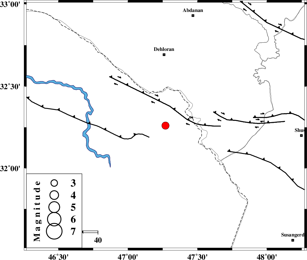
| Location | Lat:32.26 Lon: 47.27 |
| Region | Iraq, 48 km South of Dehloran |
Nearest Cities |
|
| 33 km South of Musian, Ilam Province | |
| 48 km South of Dehloran, Ilam Province | |
| 69 km South East of Bishehzar, Ilam Province | |
| 76 km South West of Sarabbagh, Ilam Province | |
| 77 km South West of Abdanan, Ilam Province | |
| Depth | 41 km |
| Agency | |
Faults within 150 km: |
|
| MFF6 (Length: 144 km) , Distance to epicenter: 48 km | |
| BALARUD_F_Z1 (Length: 87 km) , Distance to epicenter: 81 km | |
| DEZFUL_EMBAYMENT (Length: 228 km) , Distance to epicenter: 91 km | |
| Number of Phases | 7 |
| RMS | 0.2 |
| Number of Stations | 5 |
| Error in Latitude | >6.2 km |
| Error in Longitude | 9.2 km |
| Error in Depth | 5.4 km |
Download waveform in seisan format
to download seisan software Click here
to access information about IIEES stations Click here
Amplitude | ||||||||
| UID | Agency | Station | Component | Amplitude | Period | Arrival Time | Proccessing Time | Signal Clip |
| 81028 | IIEES | SHGR | N | 1037.4 | 0.41 | 2011-12-17 23:26:21 | 2011-12-17 10:56:00 | n |
| 81029 | IIEES | SHGR | E | 904.8 | 0.36 | 2011-12-17 23:26:21 | 2011-12-17 10:56:00 | n |
| 81030 | IIEES | KHMZ | N | 147.7 | 0.88 | 2011-12-17 23:27:07 | 2011-12-17 10:56:00 | n |
| 81031 | IIEES | SNGE | N | 109.3 | 0.64 | 2011-12-17 23:27:10 | 2011-12-17 10:56:00 | n |
| 81032 | IIEES | SNGE | E | 102.4 | 0.64 | 2011-12-17 23:27:18 | 2011-12-17 10:56:00 | n |
| 81033 | IIEES | ASAO | E | 61.7 | 0.52 | 2011-12-17 23:27:18 | 2011-12-17 10:56:00 | n |
| 81034 | IIEES | ASAO | N | 64.1 | 0.64 | 2011-12-17 23:27:25 | 2011-12-17 10:56:00 | n |
Phase | ||||||||||||
| Agency | Station | Component | Phase Type | Phase Quality | First Motion | Observed Arrival Time | Time Residual | Loc. Flag | Input Weight | Distance | Azimuth | |
| IIEES | SHGR | Z | Pg | E | 2011-12-17 23:26:00 | 0.04 | y | 146 | 96 | |||
| IIEES | SHGR | E | Sg | E | 2011-12-17 23:26:17 | -0.06 | y | 146 | 96 | |||
| IIEES | KHMZ | Z | Pn | E | 2011-12-17 23:26:18 | 0.1 | y | 301 | 56 | |||
| IIEES | SNGE | Z | Pn | E | 2011-12-17 23:26:20 | -0.06 | y | 315 | 1 | |||
| IIEES | SNGE | E | Sg | E | 2011-12-17 23:27:02 | 0.04 | y | 315 | 1 | |||
| IIEES | ASAO | Z | Pn | E | 2011-12-17 23:26:25 | -0.47 | y | 361 | 45 | |||
| IIEES | GHVR | Z | Pn | E | 2011-12-17 23:26:36 | 0.47 | y | 445 | 55 | |||