
Magnitude |
:4 |
| Date & Time (UTC) | 2011-12-15 05:29:47.8 |
| Date & Time (Local) | 1390/9/24 08:59:47.8 |
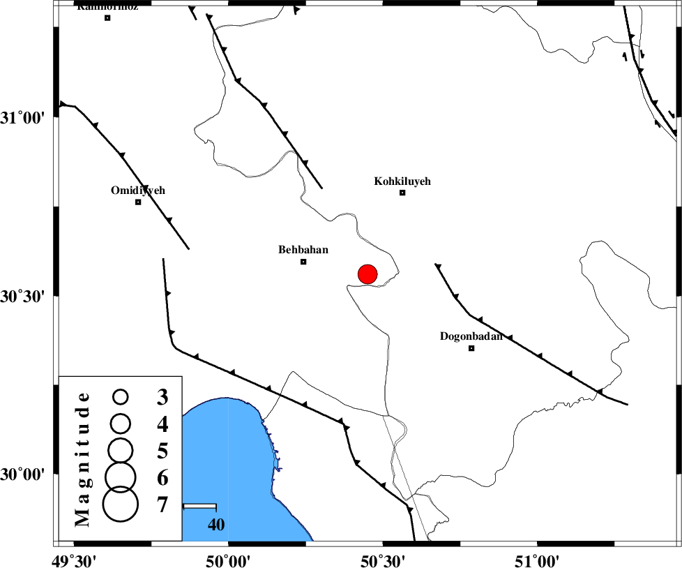
| Location | Lat:30.56 Lon: 50.45 |
| Region | Khoozestan Province, 20 km East of Behbahan |
Nearest Cities |
|
| 16 km East of Mansuriyeh, Khoozestan Province | |
| 20 km East of Behbahan, Khoozestan Province | |
| 28 km South West of Dehdasht, Kohkiluieh va boyerahmad Province | |
| 31 km South East of Dodange-ye bozorg, Khoozestan Province | |
| 35 km North East of Sardasht, Khoozestan Province | |
| Depth | 33 km |
| Agency | |
Faults within 150 km: |
|
| MISHAN_F (Length: 76 km) , Distance to epicenter: 21 km | |
| MFF4 (Length: 62 km) , Distance to epicenter: 30 km | |
| RAG_E_SEFID_F (Length: 84 km) , Distance to epicenter: 46 km | |
| Number of Phases | 6 |
| RMS | 0 |
| Number of Stations | 7 |
| Error in Latitude | >2.2 km |
| Error in Longitude | 3 km |
| Error in Depth | 5 km |
Download waveform in seisan format
to download seisan software Click here
to access information about IIEES stations Click here
Amplitude | ||||||||
| UID | Agency | Station | Component | Amplitude | Period | Arrival Time | Proccessing Time | Signal Clip |
| 81003 | IIEES | SHGR | E | 1005.4 | 0.28 | 2011-12-15 05:30:57 | 2011-12-15 04:48:00 | n |
| 81004 | IIEES | SHGR | N | 1166 | 0.72 | 2011-12-15 05:31:03 | 2011-12-15 04:48:00 | n |
| 81005 | IIEES | BNDS | N | 43.5 | 0.28 | 2011-12-15 05:32:15 | 2011-12-15 04:48:00 | n |
| 81006 | IIEES | BNDS | E | 52.3 | 0.6 | 2011-12-15 05:32:17 | 2011-12-15 04:48:00 | n |
Phase | ||||||||||||
| Agency | Station | Component | Phase Type | Phase Quality | First Motion | Observed Arrival Time | Time Residual | Loc. Flag | Input Weight | Distance | Azimuth | |
| IIEES | AHRM | Z | Pg | E | 2011-12-15 05:30:20 | 0 | y | 205 | 156 | |||
| IIEES | SHGR | Z | Pn | E | 2011-12-15 05:30:22 | -0.03 | y | 233 | 318 | |||
| IIEES | NASN | Z | Pn | E | 2011-12-15 05:30:35 | -0.06 | y | 334 | 41 | |||
| IIEES | GHIR | Z | Pn | E | 2011-12-15 05:30:37 | 0.01 | y | 352 | 135 | |||
| IIEES | KHMZ | Z | Pn | E | 2011-12-15 05:30:38 | 0.01 | y | 356 | 353 | |||
| IIEES | GHVR | Z | Pn | E | 2011-12-15 05:30:48 | 0.07 | y | 441 | 10 | |||