
Magnitude |
:2.8 |
| Date & Time (UTC) | 2011-12-12 00:24:53.9 |
| Date & Time (Local) | 1390/9/21 03:54:53.9 |
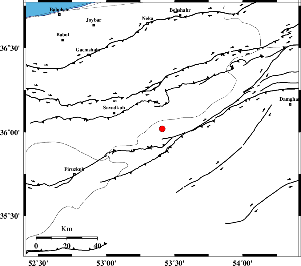
| Location | Lat:36.02 Lon: 53.41 |
| Region | Semnan Province, 33 km East of Pol-E-Sefid |
Nearest Cities |
|
| 17 km East of Sangdeh, Mazandaran Province | |
| 19 km North East of Chashem, Semnan Province | |
| 26 km South West of Kiasar, Mazandaran Province | |
| 29 km North of Shahmirzad, Semnan Province | |
| 33 km East of Shurmast-e peyrudbar, Mazandaran Province | |
| Depth | 14 km |
| Agency | |
Faults within 150 km: |
|
| N_ALBORZ_F (Length: 360 km) , Distance to epicenter: 28 km | |
| ATARI_F (Length: 185 km) , Distance to epicenter: 31 km | |
| DAMGHAN_F (Length: 95 km) , Distance to epicenter: 41 km | |
| Number of Phases | 6 |
| RMS | 0.1 |
| Number of Stations | 4 |
| Error in Latitude | >2.6 km |
| Error in Longitude | 5.5 km |
| Error in Depth | 5.7 km |
Download waveform in seisan format
to download seisan software Click here
to access information about IIEES stations Click here
Amplitude | ||||||||
| UID | Agency | Station | Component | Amplitude | Period | Arrival Time | Proccessing Time | Signal Clip |
| 80980 | IIEES | GHVR | E | 52.2 | 0.32 | 2011-12-12 00:26:16 | 2011-12-12 02:41:00 | n |
Phase | ||||||||||||
| Agency | Station | Component | Phase Type | Phase Quality | First Motion | Observed Arrival Time | Time Residual | Loc. Flag | Input Weight | Distance | Azimuth | |
| IIEES | CHTH | Z | Pg | E | 2011-12-12 00:25:27 | -0.16 | y | 206 | 267 | |||
| IIEES | CHTH | E | Sg | E | 2011-12-12 00:25:52 | 0.08 | y | 206 | 267 | |||
| IIEES | THKV | Z | P | E | 2011-12-12 00:25:30 | -0.02 | y | 228 | 268 | |||
| IIEES | GHVR | Z | Pn | E | 2011-12-12 00:25:33 | 0.01 | y | 261 | 230 | |||
| IIEES | GHVR | E | Sg | E | 2011-12-12 00:26:07 | -0.05 | y | 261 | 230 | |||
| IIEES | ASAO | Z | Pn | E | 2011-12-12 00:25:45 | 0.15 | y | 348 | 243 | |||