
Magnitude |
:3.2 |
| Date & Time (UTC) | 2011-11-26 12:04:55.2 |
| Date & Time (Local) | 1390/9/5 15:34:55.2 |
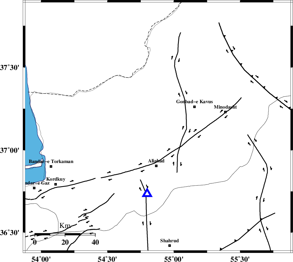
| Location | Lat:37.14 Lon: 54.88 |
| Region | Golestan Province, 26 km North of Ali Abad |
Nearest Cities |
|
| 14 km North East of Gariduji, Golestan Province | |
| 16 km West of Baghli marma, Golestan Province | |
| 17 km North West of Khanbebin, Golestan Province | |
| 20 km North West of Deland, Golestan Province | |
| 24 km South West of Soltanali, Golestan Province | |
| Depth | 27 km |
| Agency | |
Faults within 150 km: |
|
| KHAZAR_F (Length: 523 km) , Distance to epicenter: 17 km | |
| SHAVAR_F (Length: 87 km) , Distance to epicenter: 49 km | |
| ROBATE_QARABIL_F (Length: 168 km) , Distance to epicenter: 57 km | |
| Number of Phases | 5 |
| RMS | 0.1 |
| Number of Stations | 5 |
| Error in Latitude | >2.7 km |
| Error in Longitude | 5.5 km |
| Error in Depth | 3.7 km |
Download waveform in seisan format
to download seisan software Click here
to access information about IIEES stations Click here
Amplitude | ||||||||
| UID | Agency | Station | Component | Amplitude | Period | Arrival Time | Proccessing Time | Signal Clip |
| 80805 | IIEES | MRVT | E | 582 | 0.19 | 2011-11-26 12:05:32 | 2011-11-26 11:23:00 | n |
| 80806 | IIEES | SHRO | E | 256.6 | 0.27 | 2011-11-26 12:05:41 | 2011-11-26 11:23:00 | n |
Phase | ||||||||||||
| Agency | Station | Component | Phase Type | Phase Quality | First Motion | Observed Arrival Time | Time Residual | Loc. Flag | Input Weight | Distance | Azimuth | |
| IIEES | MRVT | Z | Pg | E | 2011-11-26 12:05:15 | 0.05 | y | 122 | 61 | |||
| IIEES | SHRO | Z | Pg | E | 2011-11-26 12:05:21 | -0.05 | y | 161 | 141 | |||
| IIEES | BJRD | Z | Pn | E | 2011-11-26 12:05:30 | -0.06 | y | 232 | 74 | |||
| IIEES | TABS | Z | Pn | E | 2011-11-26 12:05:56 | 0.11 | y | 437 | 152 | |||
| IIEES | NASN | Z | Pn | E | 2011-11-26 12:06:06 | -0.03 | y | 517 | 202 | |||