
Magnitude |
:3.4 |
| Date & Time (UTC) | 2011-11-25 12:51:24.4 |
| Date & Time (Local) | 1390/9/4 16:21:24.4 |
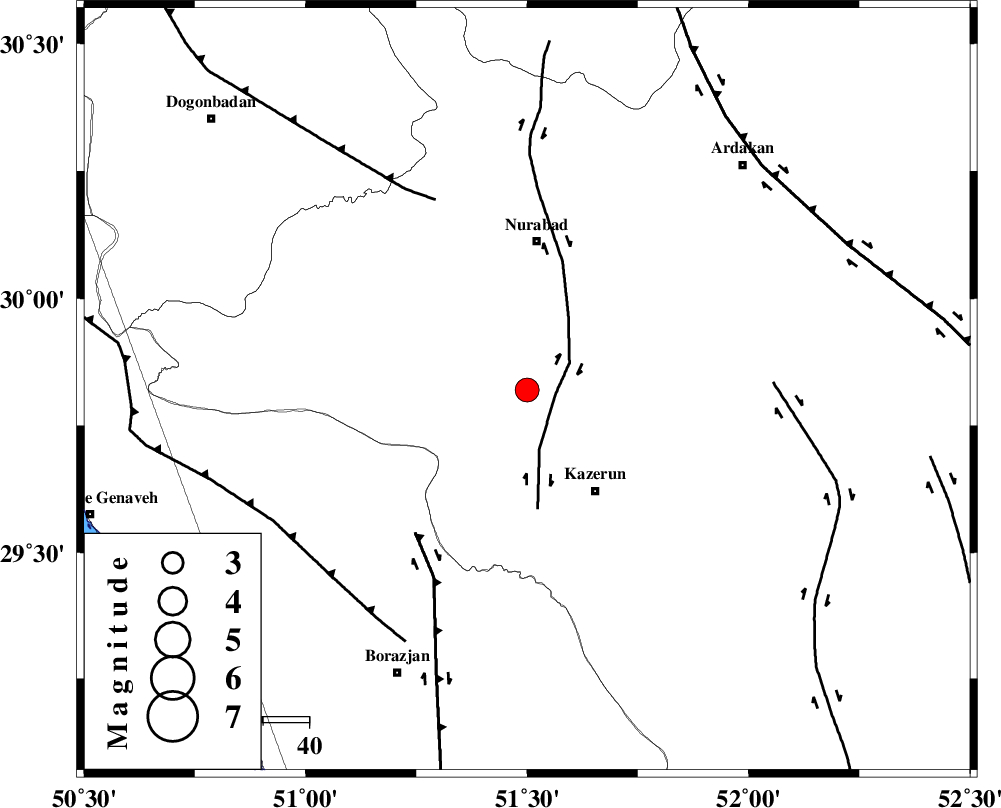
| Location | Lat:29.82 Lon: 51.5 |
| Region | Fars Province, 32 km South of Nurabad |
Nearest Cities |
|
| 13 km North West of Seyyed hasan, Fars Province | |
| 17 km North of Deris, Fars Province | |
| 20 km North West of Nodan, Fars Province | |
| 21 km North of Kamaraj, Fars Province | |
| 27 km North West of Kazerun, Fars Province | |
| Depth | 32 km |
| Agency | |
Faults within 150 km: |
|
| KAZERUN_F (Length: 96 km) , Distance to epicenter: 6 km | |
| BORAZJAN_F (Length: 168 km) , Distance to epicenter: 40 km | |
| MISHAN_F (Length: 76 km) , Distance to epicenter: 46 km | |
| Number of Phases | 6 |
| RMS | 0.1 |
| Number of Stations | 5 |
| Error in Latitude | >2.3 km |
| Error in Longitude | 3.1 km |
| Error in Depth | 5.5 km |
Download waveform in seisan format
to download seisan software Click here
to access information about IIEES stations Click here
Amplitude | ||||||||
| UID | Agency | Station | Component | Amplitude | Period | Arrival Time | Proccessing Time | Signal Clip |
| 80787 | IIEES | AHRM | E | 785 | 0.72 | 2011-11-25 12:52:01 | 2011-11-25 12:15:00 | n |
| 80788 | IIEES | AHRM | N | 809 | 0.36 | 2011-11-25 12:52:03 | 2011-11-25 12:15:00 | n |
| 80789 | IIEES | GHIR | E | 220.6 | 0.4 | 2011-11-25 12:52:37 | 2011-11-25 12:15:00 | n |
| 80790 | IIEES | SHGR | E | 79.7 | 0.44 | 2011-11-25 12:53:16 | 2011-11-25 12:15:00 | n |
| 80791 | IIEES | SHGR | N | 104.4 | 0.52 | 2011-11-25 12:53:29 | 2011-11-25 12:15:00 | n |
| 80792 | IIEES | KRBR | E | 37.6 | 0.44 | 2011-11-25 12:53:31 | 2011-11-25 12:15:00 | n |
| 80793 | IIEES | KRBR | N | 31.8 | 0.6 | 2011-11-25 12:53:32 | 2011-11-25 12:15:00 | n |
Phase | ||||||||||||
| Agency | Station | Component | Phase Type | Phase Quality | First Motion | Observed Arrival Time | Time Residual | Loc. Flag | Input Weight | Distance | Azimuth | |
| IIEES | AHRM | Z | Pg | E | 2011-11-25 12:51:42 | 0.06 | y | 108 | 190 | |||
| IIEES | AHRM | E | Sg | E | 2011-11-25 12:51:55 | -0.06 | y | 108 | 190 | |||
| IIEES | GHIR | Z | Pn | E | 2011-11-25 12:51:58 | 0.06 | y | 224 | 139 | |||
| IIEES | NASN | Z | P | E | 2011-11-25 12:52:14 | 0.05 | y | 353 | 20 | |||
| IIEES | SHGR | Z | P | E | 2011-11-25 12:52:15 | -0.03 | y | 361 | 315 | |||
| IIEES | KRBR | Z | Pn | E | 2011-11-25 12:52:33 | -0.12 | y | 509 | 87 | |||