
Magnitude |
:3 |
| Date & Time (UTC) | 2011-11-20 19:56:39.5 |
| Date & Time (Local) | 1390/8/29 23:26:39.5 |
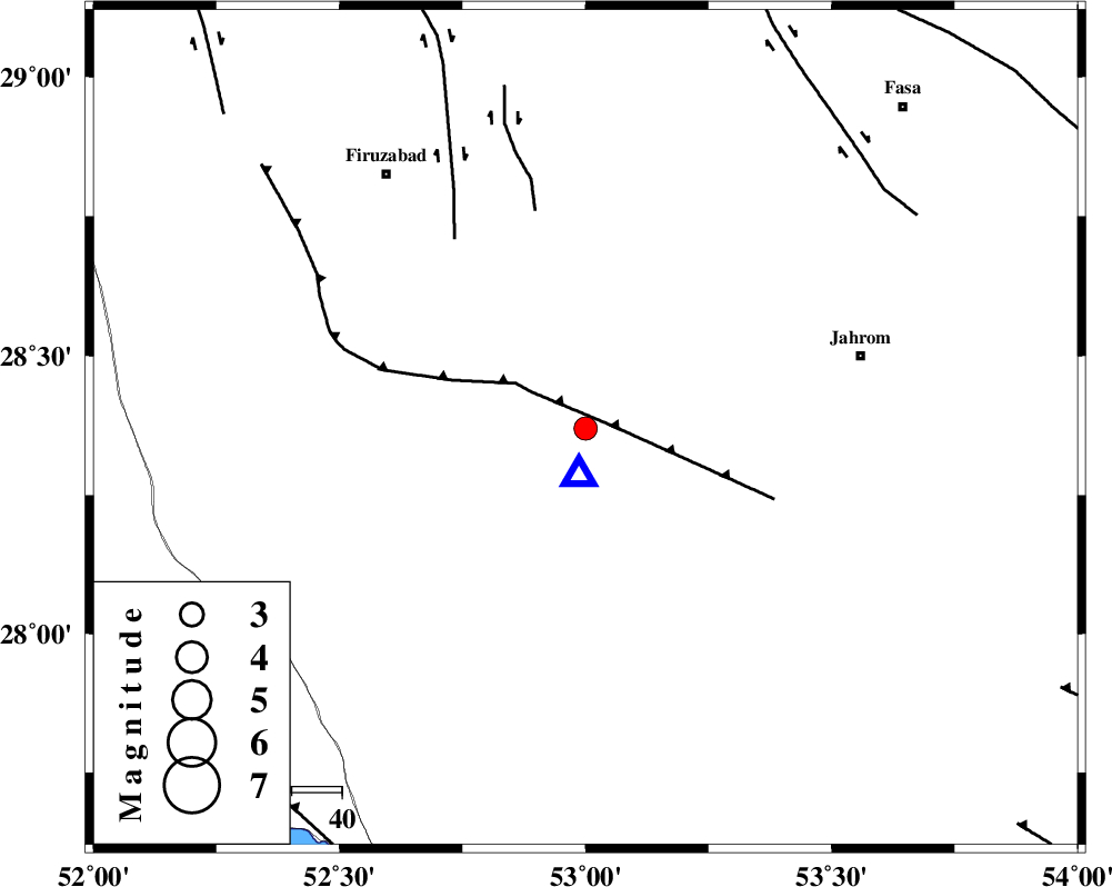
| Location | Lat:28.37 Lon: 53 |
| Region | Fars Province, 11 km Qir va Karzin |
Nearest Cities |
|
| 9 km of Shahrak-e jonubi, Fars Province | |
| 11 km of Qir va Karzin, Fars Province | |
| 18 km South West of Fathabad, Fars Province | |
| 27 km North West of Seyfabad, Fars Province | |
| 31 km South of Shaghun, Fars Province | |
| Depth | 11 km |
| Agency | |
Faults within 150 km: |
|
| QIR_F (Length: 130 km) , Distance to epicenter: 5 km | |
| SABZ_PUSHAN_F_Z2 (Length: 24 km) , Distance to epicenter: 44 km | |
| SABZ_PUSHAN_F_Z1 (Length: 69 km) , Distance to epicenter: 46 km | |
| Number of Phases | 5 |
| RMS | 0.1 |
| Number of Stations | 4 |
| Error in Latitude | >5.1 km |
| Error in Longitude | 2.6 km |
| Error in Depth | 3.7 km |
Download waveform in seisan format
to download seisan software Click here
to access information about IIEES stations Click here
Amplitude | ||||||||
| UID | Agency | Station | Component | Amplitude | Period | Arrival Time | Proccessing Time | Signal Clip |
| 80750 | IIEES | GHIR | N | 5202.1 | 0.36 | 2011-11-20 19:56:48 | 2011-11-20 07:46:00 | n |
| 80751 | IIEES | GHIR | E | 14440.4 | 0.52 | 2011-11-20 19:56:48 | 2011-11-20 07:46:00 | n |
| 80752 | IIEES | AHRM | N | 117.3 | 0.48 | 2011-11-20 19:57:38 | 2011-11-20 07:46:00 | n |
| 80753 | IIEES | KRBR | N | 13.2 | 0.6 | 2011-11-20 19:58:52 | 2011-11-20 07:46:00 | n |
Phase | ||||||||||||
| Agency | Station | Component | Phase Type | Phase Quality | First Motion | Observed Arrival Time | Time Residual | Loc. Flag | Input Weight | Distance | Azimuth | |
| IIEES | GHIR | Z | P | E | 2011-11-20 19:56:42 | -0.02 | y | 9.72 | 185 | |||
| IIEES | AHRM | Z | P | E | 2011-11-20 19:57:08 | -0.09 | y | 175 | 289 | |||
| IIEES | AHRM | N | Sg | E | 2011-11-20 19:57:31 | 0.07 | y | 175 | 289 | |||
| IIEES | BNDS | Z | P | E | 2011-11-20 19:57:28 | 0.07 | y | 331 | 108 | |||
| IIEES | KRBR | Z | Pn | E | 2011-11-20 19:57:38 | -0.03 | y | 407 | 63 | |||