
Magnitude |
:3.3 |
| Date & Time (UTC) | 2011-11-20 05:12:26.4 |
| Date & Time (Local) | 1390/8/29 08:42:26.4 |
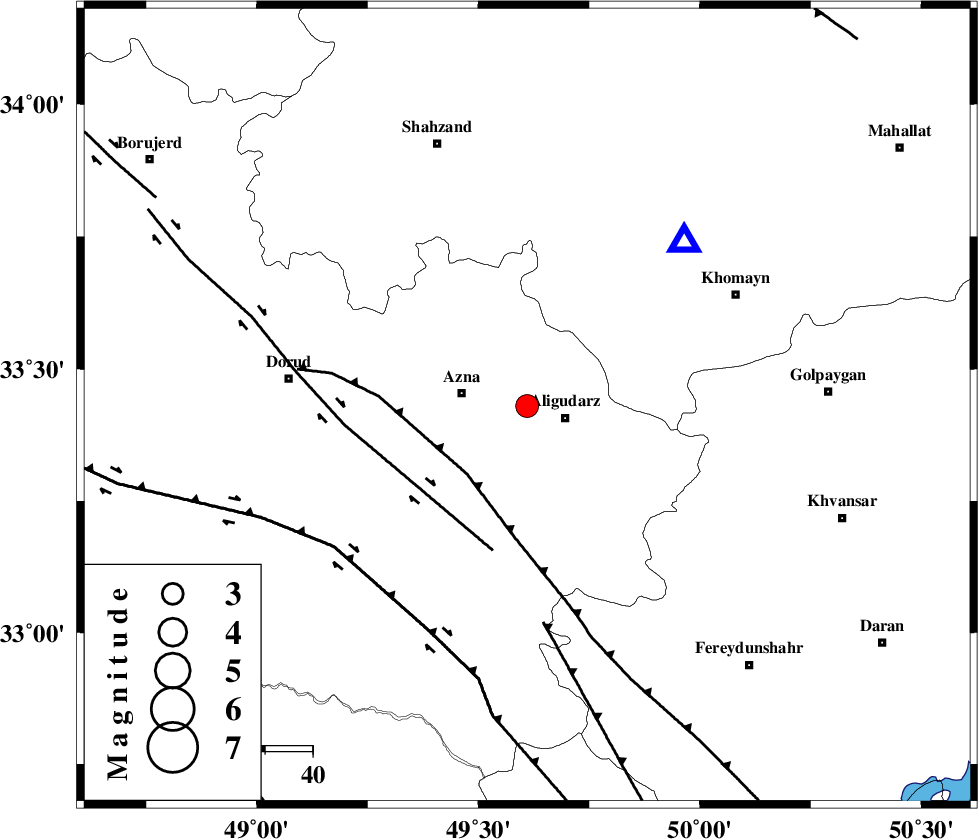
| Location | Lat:33.43 Lon: 49.61 |
| Region | Lorestan Province, 8 km Aligudarz |
Nearest Cities |
|
| 4 km North of Sur, Lorestan Province | |
| 8 km North of Aligudarz, Lorestan Province | |
| 10 km of Khameh sofla, Lorestan Province | |
| 14 km East of Azna, Lorestan Province | |
| 22 km North of Shapoorabad, Lorestan Province | |
| Depth | 6 km |
| Agency | |
Faults within 150 km: |
|
| MAIN_ZAGROS_R_F (Length: 1106 km) , Distance to epicenter: 19 km | |
| DORUD (Length: 100 km) , Distance to epicenter: 31 km | |
| ARDAL_F (Length: 170 km) , Distance to epicenter: 46 km | |
| Number of Phases | 6 |
| RMS | 0.2 |
| Number of Stations | 6 |
| Error in Latitude | >2.1 km |
| Error in Longitude | 2.9 km |
| Error in Depth | 3.8 km |
Download waveform in seisan format
to download seisan software Click here
to access information about IIEES stations Click here
Amplitude | ||||||||
| UID | Agency | Station | Component | Amplitude | Period | Arrival Time | Proccessing Time | Signal Clip |
| 80730 | IIEES | KHMZ | E | 3828.2 | 0.47 | 2011-11-20 05:12:42 | 2011-11-20 04:23:00 | n |
| 80731 | IIEES | KHMZ | N | 3362.1 | 0.18 | 2011-11-20 05:12:42 | 2011-11-20 04:23:00 | n |
| 80732 | IIEES | ASAO | N | 640.8 | 0.74 | 2011-11-20 05:13:12 | 2011-11-20 04:23:00 | n |
| 80733 | IIEES | GHVR | E | 320.7 | 0.41 | 2011-11-20 05:13:28 | 2011-11-20 04:23:00 | n |
| 80734 | IIEES | GHVR | N | 213.8 | 0.5 | 2011-11-20 05:13:32 | 2011-11-20 04:23:00 | n |
| 80735 | IIEES | SNGE | N | 159.3 | 0.66 | 2011-11-20 05:13:57 | 2011-11-20 04:23:00 | n |
Phase | ||||||||||||
| Agency | Station | Component | Phase Type | Phase Quality | First Motion | Observed Arrival Time | Time Residual | Loc. Flag | Input Weight | Distance | Azimuth | |
| IIEES | KHMZ | Z | Pg | E | 2011-11-20 05:12:35 | 0.02 | y | 47.7 | 43 | |||
| IIEES | ASAO | Z | Pg | E | 2011-11-20 05:12:48 | -0.27 | y | 130 | 17 | |||
| IIEES | SHGR | Z | Pg | E | 2011-11-20 05:12:54 | -0.12 | y | 165 | 208 | |||
| IIEES | GHVR | Z | Pg | E | 2011-11-20 05:12:59 | 0.06 | y | 191 | 52 | |||
| IIEES | SNGE | Z | Pn | E | 2011-11-20 05:13:10 | 0.22 | y | 279 | 312 | |||
| IIEES | NASN | Z | Pn | E | 2011-11-20 05:13:13 | 0.1 | y | 306 | 102 | |||