
Magnitude |
:3.3 |
| Date & Time (UTC) | 2011-11-17 19:40:57.7 |
| Date & Time (Local) | 1390/8/26 23:10:57.7 |
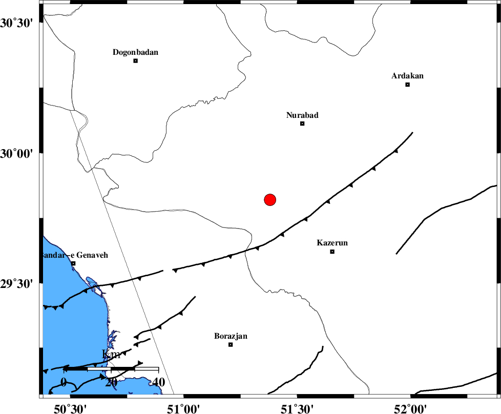
| Location | Lat:29.82 Lon: 51.38 |
| Region | Fars Province, 36 km South-West of Nurabad |
Nearest Cities |
|
| 23 km North of Kamaraj, Fars Province | |
| 24 km North West of Seyyed hasan, Fars Province | |
| 24 km North West of Deris, Fars Province | |
| 29 km North of Khesht, Fars Province | |
| 31 km North West of Nodan, Fars Province | |
| Depth | 41 km |
| Agency | |
Faults within 150 km: |
|
| KAZERUN_F (Length: 96 km) , Distance to epicenter: 18 km | |
| BORAZJAN_F (Length: 168 km) , Distance to epicenter: 34 km | |
| MISHAN_F (Length: 76 km) , Distance to epicenter: 42 km | |
| Number of Phases | 7 |
| RMS | 0.1 |
| Number of Stations | 7 |
| Error in Latitude | >3.1 km |
| Error in Longitude | 4.7 km |
| Error in Depth | 6.3 km |
Download waveform in seisan format
to download seisan software Click here
to access information about IIEES stations Click here
Amplitude | ||||||||
| UID | Agency | Station | Component | Amplitude | Period | Arrival Time | Proccessing Time | Signal Clip |
| 80704 | IIEES | AHRM | N | 747.5 | 0.44 | 2011-11-17 19:41:35 | 2011-11-17 07:05:00 | n |
| 80705 | IIEES | GHIR | E | 2960000000 | 6.36 | 2011-11-17 19:42:11 | 2011-11-17 07:05:00 | n |
| 80706 | IIEES | GHIR | N | 210.7 | 0.44 | 2011-11-17 19:42:15 | 2011-11-17 07:05:00 | n |
| 80707 | IIEES | KRBR | E | 28.6 | 0.4 | 2011-11-17 19:43:05 | 2011-11-17 07:05:00 | n |
| 80708 | IIEES | KRBR | N | 27.1 | 0.48 | 2011-11-17 19:43:12 | 2011-11-17 07:05:00 | n |
Phase | ||||||||||||
| Agency | Station | Component | Phase Type | Phase Quality | First Motion | Observed Arrival Time | Time Residual | Loc. Flag | Input Weight | Distance | Azimuth | |
| IIEES | AHRM | Z | Pg | E | 2011-11-17 19:41:15 | 0 | y | 106 | 184 | |||
| IIEES | GHIR | Z | Pn | E | 2011-11-17 19:41:31 | 0.03 | y | 231 | 137 | |||
| IIEES | NASN | Z | Pn | E | 2011-11-17 19:41:47 | -0.05 | y | 358 | 22 | |||
| IIEES | KHMZ | Z | Pn | E | 2011-11-17 19:41:59 | 0.14 | y | 455 | 343 | |||
| IIEES | KRBR | Z | Pn | E | 2011-11-17 19:42:07 | -0.05 | y | 520 | 87 | |||
| IIEES | ASAO | Z | Pn | E | 2011-11-17 19:42:10 | 0.14 | y | 540 | 347 | |||
| IIEES | SNGE | Z | Pn | E | 2011-11-17 19:42:29 | -0.33 | y | 697 | 328 | |||