
Magnitude |
:2.8 |
| Date & Time (UTC) | 2011-11-13 17:27:36.0 |
| Date & Time (Local) | 1390/8/22 20:57:36.0 |
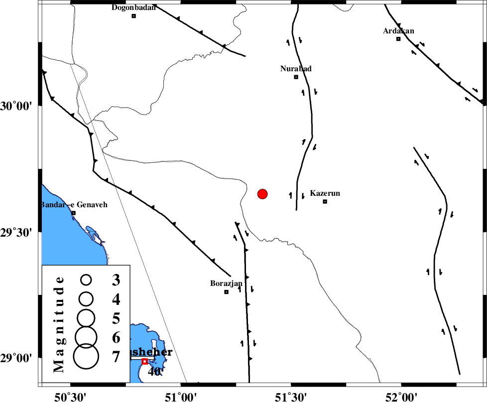
| Location | Lat:29.65 Lon: 51.37 |
| Region | Fars Province, 27 km West of Kazerun |
Nearest Cities |
|
| 10 km North of Khesht, Fars Province | |
| 10 km North West of Kamaraj, Fars Province | |
| 20 km West of Deris, Fars Province | |
| 25 km North of Dalki, Bushehr Province | |
| 28 km North West of Kazerun, Fars Province | |
| Depth | 18 km |
| Agency | |
Faults within 150 km: |
|
| KAZERUN_F (Length: 96 km) , Distance to epicenter: 16 km | |
| BORAZJAN_F (Length: 168 km) , Distance to epicenter: 17 km | |
| ZFF3 (Length: 125 km) , Distance to epicenter: 37 km | |
| Number of Phases | 5 |
| RMS | 0 |
| Number of Stations | 4 |
| Error in Latitude | >2.3 km |
| Error in Longitude | 2.5 km |
| Error in Depth | 5 km |
Download waveform in seisan format
to download seisan software Click here
to access information about IIEES stations Click here
Amplitude | ||||||||
| UID | Agency | Station | Component | Amplitude | Period | Arrival Time | Proccessing Time | Signal Clip |
| 80670 | IIEES | GHIR | N | 78.5 | 0.48 | 2011-11-13 17:28:42 | 2011-11-13 06:56:00 | n |
| 80671 | IIEES | GHIR | E | 65.3 | 0.44 | 2011-11-13 17:28:47 | 2011-11-13 06:56:00 | n |
Phase | ||||||||||||
| Agency | Station | Component | Phase Type | Phase Quality | First Motion | Observed Arrival Time | Time Residual | Loc. Flag | Input Weight | Distance | Azimuth | |
| IIEES | AHRM | Z | Pg | E | 2011-11-13 17:27:50 | -0.01 | y | 87.3 | 185 | |||
| IIEES | GHIR | Z | Pn | E | 2011-11-13 17:28:10 | 0 | y | 218 | 133 | |||
| IIEES | GHIR | N | Sg | E | 2011-11-13 17:28:37 | 0.01 | y | 218 | 133 | |||
| IIEES | NASN | Z | Pn | E | 2011-11-13 17:28:30 | -0.04 | y | 375 | 21 | |||
| IIEES | KHMZ | Z | P | E | 2011-11-13 17:28:42 | 0.04 | y | 473 | 344 | |||