
Magnitude |
:3.1 |
| Date & Time (UTC) | 2011-11-11 14:41:56.0 |
| Date & Time (Local) | 1390/8/20 18:11:56.0 |
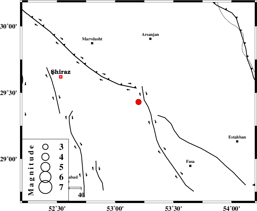
| Location | Lat:29.43 Lon: 53.2 |
| Region | Fars Province, 53 km South-West of Arsanjan |
Nearest Cities |
|
| 12 km of Kafdahak, Fars Province | |
| 17 km South of Kheyrabad-e tavalloli, Fars Province | |
| 17 km North of Sarvestan, Fars Province | |
| 19 km South of Dehqanan, Fars Province | |
| 23 km South West of Sofla, Fars Province | |
| Depth | 14 km |
| Agency | |
Faults within 150 km: |
|
| SARVESTAN_F (Length: 94 km) , Distance to epicenter: 5 km | |
| HZF3 (Length: 197 km) , Distance to epicenter: 12 km | |
| BAKHTEGAN_F (Length: 94 km) , Distance to epicenter: 19 km | |
| Number of Phases | 6 |
| RMS | 0 |
| Number of Stations | 4 |
| Error in Latitude | >1.8 km |
| Error in Longitude | 1.4 km |
| Error in Depth | 4.9 km |
Download waveform in seisan format
to download seisan software Click here
to access information about IIEES stations Click here
Amplitude | ||||||||
| UID | Agency | Station | Component | Amplitude | Period | Arrival Time | Proccessing Time | Signal Clip |
| 80646 | IIEES | GHIR | E | 358.5 | 0.6 | 2011-11-11 14:42:39 | 2011-11-11 02:16:00 | n |
| 80647 | IIEES | KRBR | N | 44.2 | 0.52 | 2011-11-11 14:43:43 | 2011-11-11 02:16:00 | n |
| 80648 | IIEES | KRBR | E | 52 | 0.52 | 2011-11-11 14:43:49 | 2011-11-11 02:16:00 | n |
Phase | ||||||||||||
| Agency | Station | Component | Phase Type | Phase Quality | First Motion | Observed Arrival Time | Time Residual | Loc. Flag | Input Weight | Distance | Azimuth | |
| IIEES | GHIR | Z | Pg | E | 2011-11-11 14:42:17 | -0.03 | y | 129 | 189 | |||
| IIEES | GHIR | E | Sg | E | 2011-11-11 14:42:33 | 0.01 | y | 129 | 189 | |||
| IIEES | AHRM | Z | Pn | E | 2011-11-11 14:42:27 | 0.01 | y | 196 | 252 | |||
| IIEES | AHRM | N | Sg | E | 2011-11-11 14:42:51 | 0.02 | y | 196 | 252 | |||
| IIEES | KRBR | Z | P | E | 2011-11-11 14:42:47 | 0.04 | y | 350 | 79 | |||
| IIEES | NASN | Z | P | E | 2011-11-11 14:42:50 | -0.04 | y | 375 | 354 | |||