
Magnitude |
:2.9 |
| Date & Time (UTC) | 2011-11-07 22:04:58.8 |
| Date & Time (Local) | 1390/8/17 01:34:58.8 |
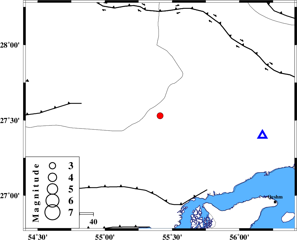
| Location | Lat:27.53 Lon: 55.41 |
| Region | Hormozgan Province, 94 km North-West of Bandar-e abbas |
Nearest Cities |
|
| 37 km South of Darz, Fars Province | |
| 50 km South West of Fin, Hormozgan Province | |
| 67 km North West of Bandar-e khamir, Hormozgan Province | |
| 78 km South East of Fadami, Fars Province | |
| 89 km South East of Doborji, Fars Province | |
| Depth | 14 km |
| Agency | |
Faults within 150 km: |
|
| MFF1 (Length: 180 km) , Distance to epicenter: 56 km | |
| LAR_F (Length: 99 km) , Distance to epicenter: 58 km | |
| HZF2 (Length: 437 km) , Distance to epicenter: 77 km | |
| Number of Phases | 6 |
| RMS | 0.1 |
| Number of Stations | 4 |
| Error in Latitude | >6.6 km |
| Error in Longitude | 2.2 km |
| Error in Depth | 4.3 km |
Download waveform in seisan format
to download seisan software Click here
to access information about IIEES stations Click here
Amplitude | ||||||||
| UID | Agency | Station | Component | Amplitude | Period | Arrival Time | Proccessing Time | Signal Clip |
| 80620 | IIEES | BNDS | N | 524.3 | 0.48 | 2011-11-07 22:05:32 | 2011-11-08 02:27:00 | n |
| 80621 | IIEES | GHIR | E | 74.8 | 0.4 | 2011-11-07 22:06:22 | 2011-11-08 02:27:00 | n |
Phase | ||||||||||||
| Agency | Station | Component | Phase Type | Phase Quality | First Motion | Observed Arrival Time | Time Residual | Loc. Flag | Input Weight | Distance | Azimuth | |
| IIEES | BNDS | Z | Pg | E | 2011-11-07 22:05:11 | -0.13 | y | 76.6 | 100 | |||
| IIEES | BNDS | E | Sg | E | 2011-11-07 22:05:21 | 0.06 | y | 76.6 | 100 | |||
| IIEES | GHIR | Z | Pn | E | 2011-11-07 22:05:38 | 0.15 | y | 253 | 290 | |||
| IIEES | GHIR | E | Sg | E | 2011-11-07 22:06:10 | -0.08 | y | 253 | 290 | |||
| IIEES | NASN | Z | Pn | E | 2011-11-07 22:06:25 | 0.06 | y | 636 | 337 | |||
| IIEES | KHMZ | Z | P | E | 2011-11-07 22:06:53 | -0.1 | y | 864 | 324 | |||