
Magnitude |
:3.1 |
| Date & Time (UTC) | 2011-11-07 15:18:41.2 |
| Date & Time (Local) | 1390/8/16 18:48:41.2 |
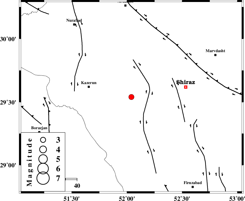
| Location | Lat:29.54 Lon: 52.04 |
| Region | Fars Province, 38 km East of Kazerun |
Nearest Cities |
|
| 13 km North West of Richi, Fars Province | |
| 17 km East of Kalani, Fars Province | |
| 23 km South West of Khanehzanian, Fars Province | |
| 30 km North East of Dadin-e olia, Fars Province | |
| 30 km North East of Baladeh, Fars Province | |
| Depth | 18 km |
| Agency | |
Faults within 150 km: |
|
| KAREBASS_F (Length: 98 km) , Distance to epicenter: 15 km | |
| SABZ_PUSHAN_F_Z3 (Length: 37 km) , Distance to epicenter: 39 km | |
| KAZERUN_F (Length: 96 km) , Distance to epicenter: 50 km | |
| Number of Phases | 6 |
| RMS | 0.1 |
| Number of Stations | 4 |
| Error in Latitude | >2 km |
| Error in Longitude | 1.5 km |
| Error in Depth | 5.1 km |
Download waveform in seisan format
to download seisan software Click here
to access information about IIEES stations Click here
Amplitude | ||||||||
| UID | Agency | Station | Component | Amplitude | Period | Arrival Time | Proccessing Time | Signal Clip |
| 80614 | IIEES | AHRM | N | 668.4 | 0.48 | 2011-11-07 15:19:18 | 2011-11-07 06:27:00 | n |
| 80615 | IIEES | GHIR | E | 372.2 | 0.48 | 2011-11-07 15:19:39 | 2011-11-07 06:27:00 | n |
| 80616 | IIEES | KRBR | N | 16.5 | 0.48 | 2011-11-07 15:20:59 | 2011-11-07 06:27:00 | n |
| 80617 | IIEES | KRBR | E | 14.6 | 0.52 | 2011-11-07 15:21:09 | 2011-11-07 06:27:00 | n |
Phase | ||||||||||||
| Agency | Station | Component | Phase Type | Phase Quality | First Motion | Observed Arrival Time | Time Residual | Loc. Flag | Input Weight | Distance | Azimuth | |
| IIEES | AHRM | Z | Pg | E | 2011-11-07 15:18:58 | 0.07 | y | 104 | 224 | |||
| IIEES | GHIR | Z | Pg | E | 2011-11-07 15:19:08 | -0.07 | y | 167 | 146 | |||
| IIEES | GHIR | E | Sg | E | 2011-11-07 15:19:29 | -0.04 | y | 167 | 146 | |||
| IIEES | NASN | Z | Pn | E | 2011-11-07 15:19:34 | -0.13 | y | 369 | 11 | |||
| IIEES | KRBR | Z | Pn | E | 2011-11-07 15:19:46 | 0.15 | y | 459 | 83 | |||
| IIEES | KRBR | E | Sg | E | 2011-11-07 15:20:49 | 0.05 | y | 459 | 83 | |||