
Magnitude |
:2.5 |
| Date & Time (UTC) | 2011-11-05 04:40:40.5 |
| Date & Time (Local) | 1390/8/14 08:10:40.5 |
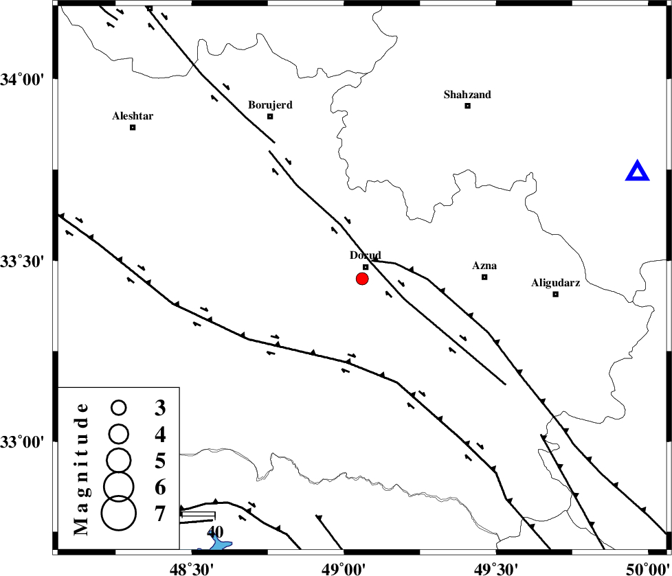
| Location | Lat:33.45 Lon: 49.06 |
| Region | Lorestan Province, 4 km Dorud |
Nearest Cities |
|
| 4 km of Dorud, Lorestan Province | |
| 11 km West of Heshmatabad, Lorestan Province | |
| 11 km of Void, Lorestan Province | |
| 13 km of Zhan, Lorestan Province | |
| 20 km South East of Kagheh, Lorestan Province | |
| Depth | 14 km |
| Agency | |
Faults within 150 km: |
|
| DORUD (Length: 100 km) , Distance to epicenter: 6 km | |
| MAIN_ZAGROS_R_F (Length: 1106 km) , Distance to epicenter: 6 km | |
| HZF4 (Length: 492 km) , Distance to epicenter: 26 km | |
| Number of Phases | 5 |
| RMS | 0.1 |
| Number of Stations | 4 |
| Error in Latitude | >4.7 km |
| Error in Longitude | 3.6 km |
| Error in Depth | 8.4 km |
Download waveform in seisan format
to download seisan software Click here
to access information about IIEES stations Click here
Amplitude | ||||||||
| UID | Agency | Station | Component | Amplitude | Period | Arrival Time | Proccessing Time | Signal Clip |
| 80603 | IIEES | ASAO | N | 85.6 | 0.55 | 2011-11-05 04:41:26 | 2011-11-05 07:58:00 | n |
| 80604 | IIEES | ASAO | E | 72.9 | 0.55 | 2011-11-05 04:41:28 | 2011-11-05 07:58:00 | n |
| 80605 | IIEES | GHVR | E | 37.3 | 0.62 | 2011-11-05 04:41:52 | 2011-11-05 07:58:00 | n |
| 80606 | IIEES | SNGE | N | 32.8 | 0.35 | 2011-11-05 04:41:53 | 2011-11-05 07:58:00 | n |
| 80607 | IIEES | SNGE | E | 34.8 | 0.58 | 2011-11-05 04:41:54 | 2011-11-05 07:58:00 | n |
Phase | ||||||||||||
| Agency | Station | Component | Phase Type | Phase Quality | First Motion | Observed Arrival Time | Time Residual | Loc. Flag | Input Weight | Distance | Azimuth | |
| IIEES | ASAO | Z | Pg | E | 2011-11-05 04:41:05 | -0.26 | y | 151 | 36 | |||
| IIEES | ASAO | N | Sg | E | 2011-11-05 04:41:24 | 0.13 | y | 151 | 36 | |||
| IIEES | GHVR | Z | Pn | E | 2011-11-05 04:41:17 | 0.01 | y | 232 | 60 | |||
| IIEES | SNGE | Z | Pn | E | 2011-11-05 04:41:18 | 0.06 | y | 241 | 320 | |||
| IIEES | NASN | Z | Pn | E | 2011-11-05 04:41:32 | 0.07 | y | 357 | 101 | |||