
Magnitude |
:3.3 |
| Date & Time (UTC) | 2011-11-01 00:19:23.5 |
| Date & Time (Local) | 1390/8/10 03:49:23.5 |
| Location | Lat:28.16 Lon: 54.43 |
| Region | Fars Province, 55 km North of Lar |
Nearest Cities |
|
| 19 km South of Shahr-e pir, Fars Province | |
| 22 km South of Hajiabad, Fars Province | |
| 34 km North of Dehkuyeh, Fars Province | |
| 36 km South East of Dabiran, Fars Province | |
| 51 km North of Latifi, Fars Province | |
| Depth | 31 km |
| Agency | |
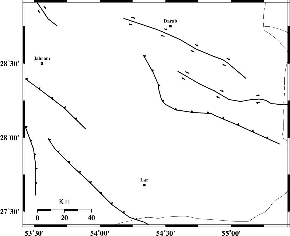
Faults within 150 km: |
|
| HZF2 (Length: 437 km) , Distance to epicenter: 36 km | |
| BERIZ_F (Length: 49 km) , Distance to epicenter: 45 km | |
| HZF1 (Length: 102 km) , Distance to epicenter: 57 km | |
| Number of Phases | 5 |
| RMS | 0.1 |
| Number of Stations | 3 |
| Error in Latitude | >5.4 km |
| Error in Longitude | 2.5 km |
| Error in Depth | 5.3 km |
Download waveform in seisan format
to download seisan software Click here
to access information about IIEES stations Click here
Amplitude | ||||||||
| UID | Agency | Station | Component | Amplitude | Period | Arrival Time | Proccessing Time | Signal Clip |
| 80585 | IIEES | GHIR | E | 846.9 | 0.44 | 2011-11-01 00:20:09 | 2011-11-01 12:25:00 | n |
| 80586 | IIEES | BNDS | N | 290.1 | 0.52 | 2011-11-01 00:20:30 | 2011-11-01 12:25:00 | n |
| 80587 | IIEES | BNDS | E | 233.6 | 0.44 | 2011-11-01 00:20:31 | 2011-11-01 12:25:00 | n |
Phase | ||||||||||||
| Agency | Station | Component | Phase Type | Phase Quality | First Motion | Observed Arrival Time | Time Residual | Loc. Flag | Input Weight | Distance | Azimuth | |
| IIEES | GHIR | Z | Pg | E | 2011-11-01 00:19:47 | 0.21 | y | 143 | 276 | |||
| IIEES | GHIR | E | Sg | E | 2011-11-01 00:20:04 | -0.15 | y | 143 | 276 | |||
| IIEES | BNDS | Z | Pn | E | 2011-11-01 00:19:53 | 0.01 | y | 191 | 116 | |||
| IIEES | BNDS | E | Sg | E | 2011-11-01 00:20:17 | -0.04 | y | 191 | 116 | |||
| IIEES | NASN | Z | Pn | E | 2011-11-01 00:20:36 | -0.04 | y | 537 | 344 | |||