
Magnitude |
:2.5 |
| Date & Time (UTC) | 2011-10-29 04:20:53.4 |
| Date & Time (Local) | 1390/8/7 07:50:53.4 |
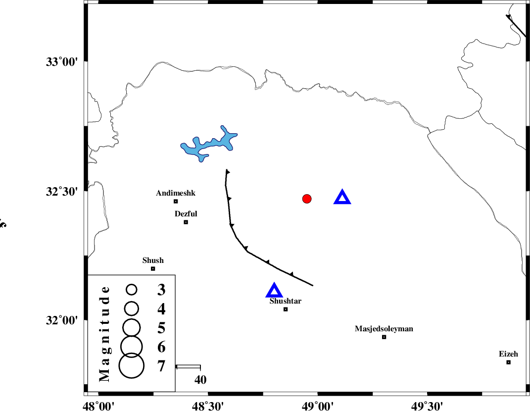
| Location | Lat:32.47 Lon: 48.95 |
| Region | Khoozestan Province, 18 km West of Lali |
Nearest Cities |
|
| 11 km East of Sardasht, Khoozestan Province | |
| 17 km North West of Lali, Khoozestan Province | |
| 27 km North West of Jaefarabad, Khoozestan Province | |
| 28 km North East of Gatvand, Khoozestan Province | |
| 28 km North East of Mahur berenji, Khoozestan Province | |
| Depth | 17 km |
| Agency | |
Faults within 150 km: |
|
| DEZFUL_EMBAYMENT (Length: 228 km) , Distance to epicenter: 21 km | |
| MFF2 (Length: 205 km) , Distance to epicenter: 21 km | |
| BALARUD_F_Z2 (Length: 58 km) , Distance to epicenter: 25 km | |
| Number of Phases | 4 |
| RMS | 0 |
| Number of Stations | 4 |
| Error in Latitude | >3.3 km |
| Error in Longitude | 5.6 km |
| Error in Depth | 5.3 km |
Download waveform in seisan format
to download seisan software Click here
to access information about IIEES stations Click here
Amplitude | ||||||||
| UID | Agency | Station | Component | Amplitude | Period | Arrival Time | Proccessing Time | Signal Clip |
| 80561 | IIEES | SHGR | N | 483.7 | 0.2 | 2011-10-29 04:21:11 | 2011-10-29 04:33:00 | n |
| 80562 | IIEES | SHGR | E | 511.8 | 0.35 | 2011-10-29 04:21:15 | 2011-10-29 04:33:00 | n |
Phase | ||||||||||||
| Agency | Station | Component | Phase Type | Phase Quality | First Motion | Observed Arrival Time | Time Residual | Loc. Flag | Input Weight | Distance | Azimuth | |
| IIEES | SHGR | Z | Pg | E | 2011-10-29 04:21:01 | -0.01 | y | 42.6 | 199 | |||
| IIEES | KHMZ | Z | Pg | E | 2011-10-29 04:21:21 | 0 | y | 170 | 34 | |||
| IIEES | ASAO | Z | Pn | E | 2011-10-29 04:21:32 | 0 | y | 251 | 23 | |||
| IIEES | SNGE | Z | Pn | E | 2011-10-29 04:21:41 | 0.01 | y | 326 | 333 | |||