
Magnitude |
:3.4 |
| Date & Time (UTC) | 2011-10-28 05:19:33.5 |
| Date & Time (Local) | 1390/8/6 08:49:33.5 |
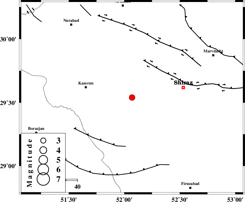
| Location | Lat:29.54 Lon: 52.07 |
| Region | Fars Province, 41 km East of Kazerun |
Nearest Cities |
|
| 10 km North of Richi, Fars Province | |
| 20 km East of Kalani, Fars Province | |
| 20 km South West of Khanehzanian, Fars Province | |
| 31 km North East of Baladeh, Fars Province | |
| 32 km North East of Dadin-e olia, Fars Province | |
| Depth | 14 km |
| Agency | |
Faults within 150 km: |
|
| KAREBASS_F (Length: 98 km) , Distance to epicenter: 12 km | |
| SABZ_PUSHAN_F_Z3 (Length: 37 km) , Distance to epicenter: 37 km | |
| KAZERUN_F (Length: 96 km) , Distance to epicenter: 53 km | |
| Number of Phases | 6 |
| RMS | 0.1 |
| Number of Stations | 4 |
| Error in Latitude | >3.4 km |
| Error in Longitude | 1.4 km |
| Error in Depth | 8.9 km |
Download waveform in seisan format
to download seisan software Click here
to access information about IIEES stations Click here
Amplitude | ||||||||
| UID | Agency | Station | Component | Amplitude | Period | Arrival Time | Proccessing Time | Signal Clip |
| 80541 | IIEES | AHRM | E | 892.9 | 0.44 | 2011-10-28 05:20:08 | 2011-10-28 05:46:00 | n |
| 80542 | IIEES | AHRM | N | 986.4 | 0.4 | 2011-10-28 05:20:09 | 2011-10-28 05:46:00 | n |
| 80543 | IIEES | GHIR | E | 659.9 | 0.36 | 2011-10-28 05:20:30 | 2011-10-28 05:46:00 | n |
Phase | ||||||||||||
| Agency | Station | Component | Phase Type | Phase Quality | First Motion | Observed Arrival Time | Time Residual | Loc. Flag | Input Weight | Distance | Azimuth | |
| IIEES | AHRM | Z | Pg | E | 2011-10-28 05:19:51 | -0.02 | y | 105 | 225 | |||
| IIEES | AHRM | E | Sg | E | 2011-10-28 05:20:04 | 0.04 | y | 105 | 225 | |||
| IIEES | GHIR | Z | Pg | E | 2011-10-28 05:20:00 | -0.14 | y | 165 | 147 | |||
| IIEES | GHIR | E | Sg | E | 2011-10-28 05:20:20 | 0.09 | y | 165 | 147 | |||
| IIEES | KRBR | Z | Pn | E | 2011-10-28 05:20:38 | 0.03 | y | 457 | 83 | |||
| IIEES | KHMZ | Z | Pn | E | 2011-10-28 05:20:44 | 0.01 | y | 507 | 337 | |||