
Magnitude |
:3 |
| Date & Time (UTC) | 2011-10-23 01:36:10.2 |
| Date & Time (Local) | 1390/8/1 05:06:10.2 |
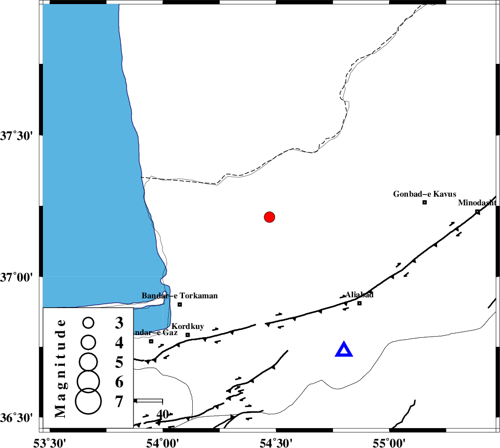
| Location | Lat:37.21 Lon: 54.47 |
| Region | Golestan Province, 22 km North of Aq Qaleh |
Nearest Cities |
|
| 22 km North of Aq Qaleh, Golestan Province | |
| 22 km North of Qanqarmeh, Golestan Province | |
| 27 km North West of Gariduji, Golestan Province | |
| 28 km North West of Nodeh malek, Golestan Province | |
| 31 km North East of Banavar, Golestan Province | |
| Depth | 14 km |
| Agency | |
Faults within 150 km: |
|
| KHAZAR_F (Length: 523 km) , Distance to epicenter: 40 km | |
| N_ALBORZ_F (Length: 360 km) , Distance to epicenter: 67 km | |
| SHAVAR_F (Length: 87 km) , Distance to epicenter: 72 km | |
| Number of Phases | 4 |
| RMS | 0 |
| Number of Stations | 5 |
| Error in Latitude | >2.9 km |
| Error in Longitude | 3 km |
| Error in Depth | 4.8 km |
Download waveform in seisan format
to download seisan software Click here
to access information about IIEES stations Click here
Amplitude | ||||||||
| UID | Agency | Station | Component | Amplitude | Period | Arrival Time | Proccessing Time | Signal Clip |
| 80522 | IIEES | MRVT | E | 226.9 | 0.13 | 2011-10-23 01:36:53 | 2011-10-23 02:56:00 | n |
| 80523 | IIEES | THKV | N | 31.2 | 0.24 | 2011-10-23 01:37:59 | 2011-10-23 02:56:00 | n |
| 80524 | IIEES | GRMI | E | 8.9 | 0.2 | 2011-10-23 01:38:37 | 2011-10-23 02:56:00 | n |
| 80525 | IIEES | GRMI | N | 7.1 | 0.46 | 2011-10-23 01:38:38 | 2011-10-23 02:56:00 | n |
Phase | ||||||||||||
| Agency | Station | Component | Phase Type | Phase Quality | First Motion | Observed Arrival Time | Time Residual | Loc. Flag | Input Weight | Distance | Azimuth | |
| IIEES | MRVT | Z | Pg | E | 2011-10-23 01:36:35 | -0.02 | y | 152 | 70 | |||
| IIEES | SHRO | Z | Pg | E | 2011-10-23 01:36:41 | 0 | y | 191 | 133 | |||
| IIEES | BJRD | Z | Pn | E | 2011-10-23 01:36:51 | 0.02 | y | 266 | 77 | |||
| IIEES | GRMI | Z | Pn | E | 2011-10-23 01:37:33 | -0.01 | y | 604 | 289 | |||