
Magnitude |
:2.7 |
| Date & Time (UTC) | 2011-10-16 01:05:25.6 |
| Date & Time (Local) | 1390/7/24 04:35:25.6 |
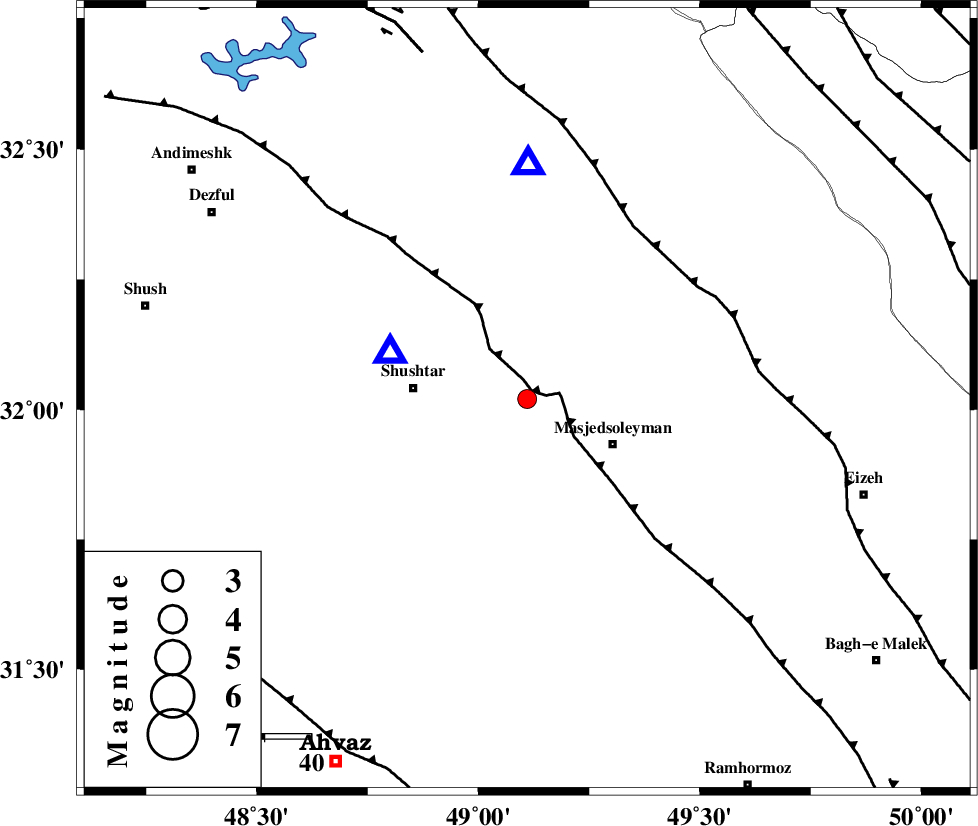
| Location | Lat:32.02 Lon: 49.11 |
| Region | Khoozestan Province, 20 km West of Masjed Soleyman |
Nearest Cities |
|
| 13 km South of Haft shahidan, Khoozestan Province | |
| 21 km North West of Masjed Soleyman, Khoozestan Province | |
| 24 km East of Shushtar, Khoozestan Province | |
| 26 km North East of Mehdiabad, Khoozestan Province | |
| 28 km South of Jaefarabad, Khoozestan Province | |
| Depth | 14 km |
| Agency | |
Faults within 150 km: |
|
| DEZFUL_EMBAYMENT (Length: 228 km) , Distance to epicenter: 2 km | |
| MFF2 (Length: 205 km) , Distance to epicenter: 43 km | |
| BALARUD_F_Z2 (Length: 58 km) , Distance to epicenter: 77 km | |
| Number of Phases | 5 |
| RMS | 0.2 |
| Number of Stations | 4 |
| Error in Latitude | >5.9 km |
| Error in Longitude | 3.2 km |
| Error in Depth | 6.7 km |
Download waveform in seisan format
to download seisan software Click here
to access information about IIEES stations Click here
Amplitude | ||||||||
| UID | Agency | Station | Component | Amplitude | Period | Arrival Time | Proccessing Time | Signal Clip |
| 80447 | IIEES | SHGR | N | 1401.2 | 0.33 | 2011-10-16 01:05:38 | 2011-10-16 02:40:00 | n |
| 80448 | IIEES | SHGR | E | 1241.9 | 0.51 | 2011-10-16 01:05:40 | 2011-10-16 02:40:00 | n |
| 80449 | IIEES | KHMZ | E | 42.5 | 0.29 | 2011-10-16 01:06:29 | 2011-10-16 02:40:00 | n |
| 80450 | IIEES | KHMZ | N | 166.2 | 0.97 | 2011-10-16 01:06:30 | 2011-10-16 02:40:00 | n |
| 80451 | IIEES | ASAO | N | 16.9 | 0.7 | 2011-10-16 01:06:54 | 2011-10-16 02:40:00 | n |
Phase | ||||||||||||
| Agency | Station | Component | Phase Type | Phase Quality | First Motion | Observed Arrival Time | Time Residual | Loc. Flag | Input Weight | Distance | Azimuth | |
| IIEES | SHGR | Z | Pg | E | 2011-10-16 01:05:31 | -0.24 | y | 31.2 | 289 | |||
| IIEES | SHGR | E | Sg | E | 2011-10-16 01:05:36 | 0.17 | y | 31.2 | 289 | |||
| IIEES | KHMZ | Z | Pg | E | 2011-10-16 01:05:59 | -0.13 | y | 207 | 22 | |||
| IIEES | ASAO | Z | Pn | E | 2011-10-16 01:06:10 | 0.12 | y | 293 | 17 | |||
| IIEES | NASN | Z | Pn | E | 2011-10-16 01:06:18 | 0.1 | y | 358 | 75 | |||