
Magnitude |
:3 |
| Date & Time (UTC) | 2011-10-11 07:36:40.5 |
| Date & Time (Local) | 1390/7/19 11:06:40.5 |
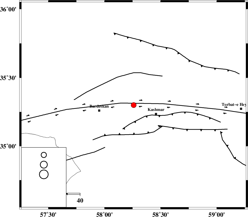
| Location | Lat:35.3 Lon: 58.26 |
| Region | Khorasan(center) Province, 20 km West of Kashmar |
Nearest Cities |
|
| 7 km North of Khalilabad, Khorasan(center) Province | |
| 15 km North West of Kasrineh, Khorasan(center) Province | |
| 16 km North East of Konder, Khorasan(center) Province | |
| 19 km North West of Kashmar, Khorasan(center) Province | |
| 23 km South West of Toroq, Khorasan(center) Province | |
| Depth | 15 km |
| Agency | |
Faults within 150 km: |
|
| DORUNEH_F (Length: 713 km) , Distance to epicenter: 10 km | |
| KASHMAR_F (Length: 91 km) , Distance to epicenter: 13 km | |
| MEHDIABAD_F (Length: 64 km) , Distance to epicenter: 24 km | |
| Number of Phases | 4 |
| RMS | 0.2 |
| Number of Stations | 4 |
| Error in Latitude | >3.5 km |
| Error in Longitude | 2.2 km |
| Error in Depth | 0 km |
Download waveform in seisan format
to download seisan software Click here
to access information about IIEES stations Click here
Amplitude | ||||||||
| UID | Agency | Station | Component | Amplitude | Period | Arrival Time | Proccessing Time | Signal Clip |
| 80439 | IIEES | TABS | E | 65.8 | 0.26 | 2011-10-11 07:37:47 | 2011-10-11 07:53:00 | n |
| 80440 | IIEES | TABS | N | 123.1 | 0.23 | 2011-10-11 07:37:49 | 2011-10-11 07:53:00 | n |
| 80441 | IIEES | SHRT | N | 99 | 0.33 | 2011-10-11 07:37:59 | 2011-10-11 07:53:00 | n |
| 80442 | IIEES | SHRT | E | 95.9 | 0.37 | 2011-10-11 07:38:07 | 2011-10-11 07:53:00 | n |
Phase | ||||||||||||
| Agency | Station | Component | Phase Type | Phase Quality | First Motion | Observed Arrival Time | Time Residual | Loc. Flag | Input Weight | Distance | Azimuth | |
| IIEES | TABS | Z | Pn | E | 2011-10-11 07:37:14 | 0.16 | y | 211 | 210 | |||
| IIEES | SHRO | Z | Pn | E | 2011-10-11 07:37:15 | -0.3 | y | 218 | 292 | |||
| IIEES | SHRT | Z | Pn | E | 2011-10-11 07:37:20 | -0.09 | y | 262 | 134 | |||
| IIEES | MRVT | Z | Pn | E | 2011-10-11 07:37:28 | 0.26 | y | 326 | 324 | |||