
Magnitude |
:3.1 |
| Date & Time (UTC) | 2011-10-08 01:58:28.8 |
| Date & Time (Local) | 1390/7/16 05:28:28.8 |
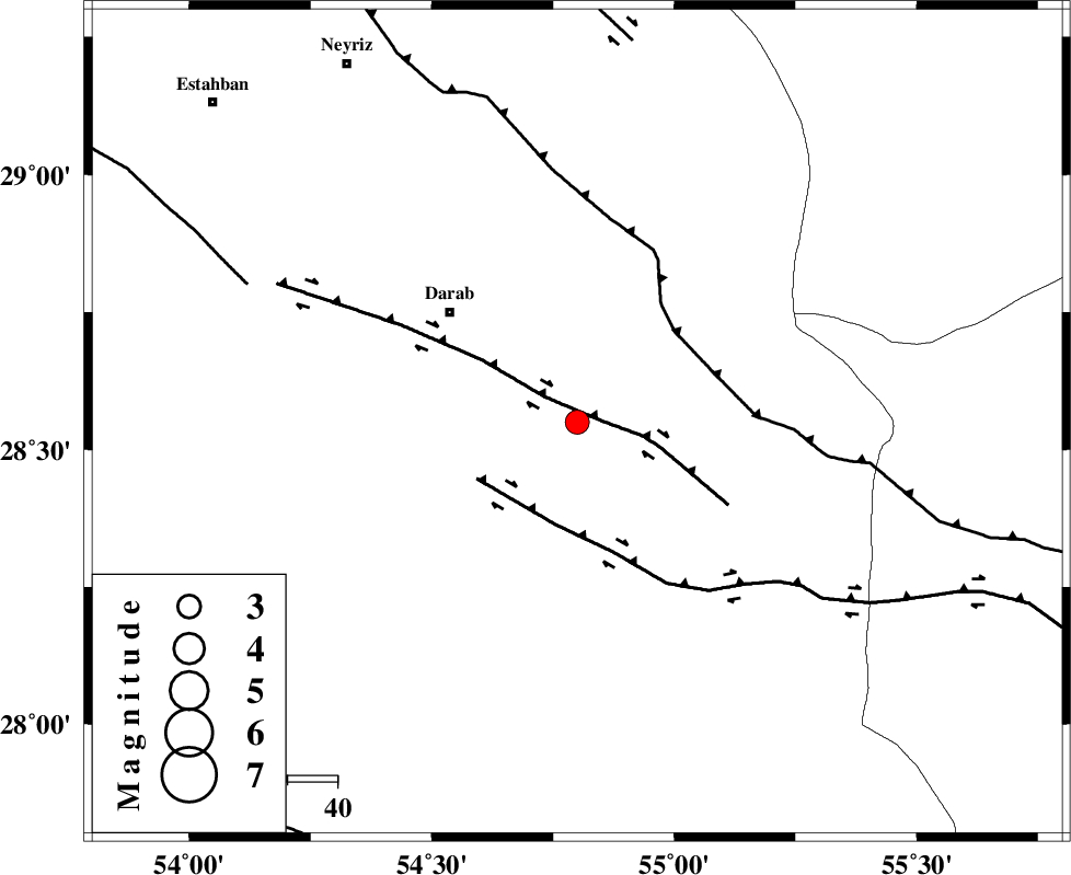
| Location | Lat:28.55 Lon: 54.8 |
| Region | Fars Province, 34 km South-East of Darab |
Nearest Cities |
|
| 15 km East of Dehkheyr, Fars Province | |
| 29 km North West of Rostaq, Fars Province | |
| 33 km South East of Shahnan, Fars Province | |
| 34 km South East of Darab, Fars Province | |
| 37 km South East of Sang-e charak, Fars Province | |
| Depth | 18 km |
| Agency | |
Faults within 150 km: |
|
| HZF1 (Length: 102 km) , Distance to epicenter: 5 km | |
| HZF2 (Length: 437 km) , Distance to epicenter: 21 km | |
| MAIN_ZAGROS_R_F (Length: 1106 km) , Distance to epicenter: 27 km | |
| Number of Phases | 5 |
| RMS | 0.1 |
| Number of Stations | 3 |
| Error in Latitude | >2.7 km |
| Error in Longitude | 1.3 km |
| Error in Depth | 4.3 km |
Download waveform in seisan format
to download seisan software Click here
to access information about IIEES stations Click here
Amplitude | ||||||||
| UID | Agency | Station | Component | Amplitude | Period | Arrival Time | Proccessing Time | Signal Clip |
| 80406 | IIEES | GHIR | E | 174.3 | 0.36 | 2011-10-08 01:59:21 | 2011-10-08 02:12:00 | n |
| 80407 | IIEES | BNDS | N | 249.7 | 0.48 | 2011-10-08 01:59:31 | 2011-10-08 02:12:00 | n |
| 80408 | IIEES | BNDS | E | 164.8 | 0.52 | 2011-10-08 01:59:34 | 2011-10-08 02:12:00 | n |
Phase | ||||||||||||
| Agency | Station | Component | Phase Type | Phase Quality | First Motion | Observed Arrival Time | Time Residual | Loc. Flag | Input Weight | Distance | Azimuth | |
| IIEES | GHIR | Z | Pn | E | 2011-10-08 01:58:58 | -0.13 | y | 180 | 261 | |||
| IIEES | GHIR | E | Sg | E | 2011-10-08 01:59:20 | 0.08 | y | 180 | 261 | |||
| IIEES | BNDS | Z | Pn | E | 2011-10-08 01:58:59 | -0.01 | y | 185 | 133 | |||
| IIEES | BNDS | E | Sg | E | 2011-10-08 01:59:21 | 0.01 | y | 185 | 133 | |||
| IIEES | KRBR | N | Pn | E | 2011-10-08 01:59:07 | 0.04 | y | 248 | 50 | |||