
Magnitude |
:3.3 |
| Date & Time (UTC) | 2011-10-02 01:28:32.9 |
| Date & Time (Local) | 1390/7/10 04:58:32.9 |
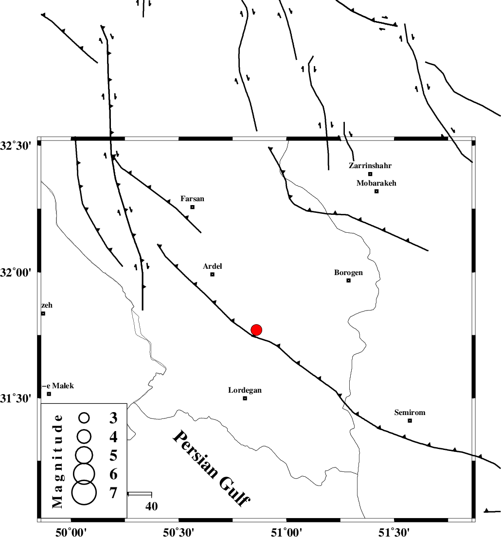
| Location | Lat:31.77 Lon: 50.86 |
| Region | Chaharmahal Bakhtiari Province, 30 km North of Lordegan |
Nearest Cities |
|
| 17 km North of Armand-e olia, Chaharmahal Bakhtiari Province | |
| 22 km South East of Naghan, Chaharmahal Bakhtiari Province | |
| 25 km South West of Baladaji, Chaharmahal Bakhtiari Province | |
| 29 km South East of Dupelan, Chaharmahal Bakhtiari Province | |
| 30 km North East of Sarkhun, Chaharmahal Bakhtiari Province | |
| Depth | 14 km |
| Agency | |
Faults within 150 km: |
|
| DOPOLAN_F (Length: 107 km) , Distance to epicenter: 2 km | |
| SABZKUH_F (Length: 67 km) , Distance to epicenter: 5 km | |
| ARDAL_F (Length: 170 km) , Distance to epicenter: 14 km | |
| Number of Phases | 4 |
| RMS | 0.2 |
| Number of Stations | 4 |
| Error in Latitude | >6.2 km |
| Error in Longitude | 2.9 km |
| Error in Depth | 6.3 km |
Download waveform in seisan format
to download seisan software Click here
to access information about IIEES stations Click here
Amplitude | ||||||||
| UID | Agency | Station | Component | Amplitude | Period | Arrival Time | Proccessing Time | Signal Clip |
| 80343 | IIEES | SHGR | E | 254.9 | 0.08 | 2011-10-02 01:29:40 | 2011-10-02 01:58:00 | n |
| 80344 | IIEES | SHGR | N | 256 | 0.66 | 2011-10-02 01:29:42 | 2011-10-02 01:58:00 | n |
| 80345 | IIEES | NASN | E | 247.3 | 0.67 | 2011-10-02 01:29:39 | 2011-10-02 01:58:00 | n |
| 80346 | IIEES | NASN | N | 281.3 | 0.45 | 2011-10-02 01:29:49 | 2011-10-02 01:58:00 | n |
| 80347 | IIEES | KHMZ | N | 212.7 | 0.85 | 2011-10-02 01:29:48 | 2011-10-02 01:58:00 | n |
| 80348 | IIEES | ASAO | E | 76.5 | 0.41 | 2011-10-02 01:30:13 | 2011-10-02 01:58:00 | n |
Phase | ||||||||||||
| Agency | Station | Component | Phase Type | Phase Quality | First Motion | Observed Arrival Time | Time Residual | Loc. Flag | Input Weight | Distance | Azimuth | |
| IIEES | SHGR | Z | Pg | E | 2011-10-02 01:29:05 | -0.02 | y | 198 | 282 | |||
| IIEES | NASN | Z | Pg | E | 2011-10-02 01:29:08 | -0.04 | y | 217 | 58 | |||
| IIEES | KHMZ | Z | Pg | E | 2011-10-02 01:29:11 | -0.17 | y | 234 | 339 | |||
| IIEES | ASAO | Z | Pn | E | 2011-10-02 01:29:20 | 0.26 | y | 318 | 346 | |||