
Magnitude |
:3.9 |
| Date & Time (UTC) | 2011-09-26 15:51:50.8 |
| Date & Time (Local) | 1390/7/4 19:21:50.8 |
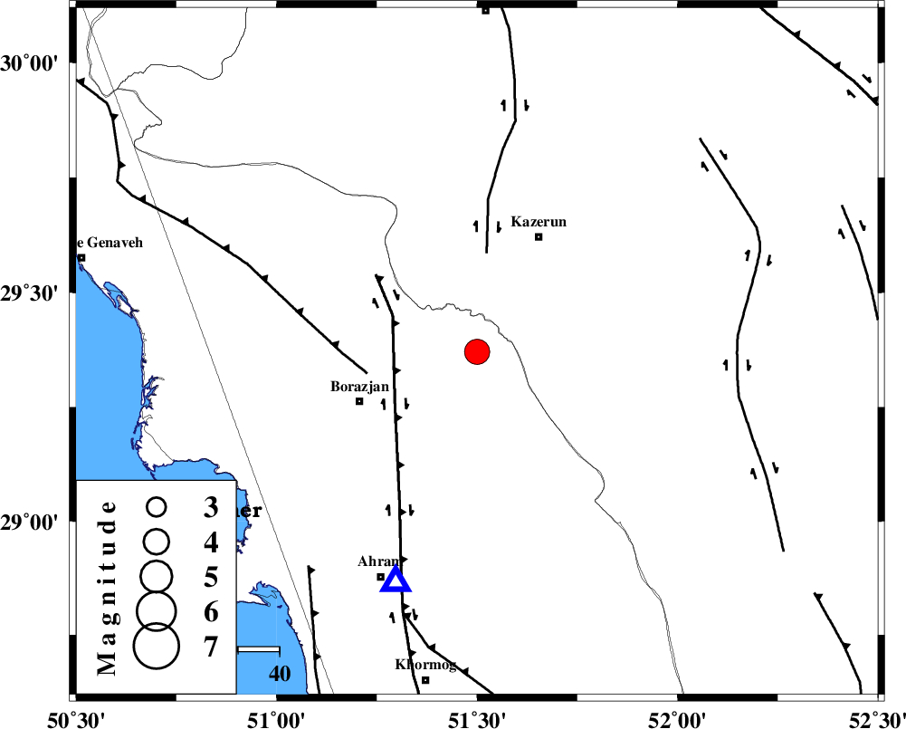
| Location | Lat:29.37 Lon: 51.5 |
| Region | Bushehr Province, 31 km South-West of Kazerun |
Nearest Cities |
|
| 21 km East of Dalki, Bushehr Province | |
| 26 km South West of Mehranjan, Fars Province | |
| 27 km South East of Khesht, Fars Province | |
| 29 km South of Kamaraj, Fars Province | |
| 31 km East of Nazar aqa, Bushehr Province | |
| Depth | 14 km |
| Agency | |
Faults within 150 km: |
|
| BORAZJAN_F (Length: 168 km) , Distance to epicenter: 22 km | |
| KAZERUN_F (Length: 96 km) , Distance to epicenter: 24 km | |
| ZFF3 (Length: 125 km) , Distance to epicenter: 27 km | |
| Number of Phases | 8 |
| RMS | 0.2 |
| Number of Stations | 7 |
| Error in Latitude | >3.7 km |
| Error in Longitude | 3.4 km |
| Error in Depth | 8.6 km |
Download waveform in seisan format
to download seisan software Click here
to access information about IIEES stations Click here
Amplitude | ||||||||
| UID | Agency | Station | Component | Amplitude | Period | Arrival Time | Proccessing Time | Signal Clip |
| 80319 | IIEES | AHRM | N | 10393.5 | 0.52 | 2011-09-26 15:52:10 | 2011-09-26 04:18:00 | n |
| 80320 | IIEES | AHRM | E | 8389.7 | 0.36 | 2011-09-26 15:52:11 | 2011-09-26 04:18:00 | n |
| 80321 | IIEES | GHIR | E | 1626.5 | 0.6 | 2011-09-26 15:52:56 | 2011-09-26 04:18:00 | n |
| 80322 | IIEES | ASAO | E | 58.3 | 0.6 | 2011-09-26 15:54:16 | 2011-09-26 04:18:00 | n |
| 80323 | IIEES | ASAO | N | 64.3 | 0.76 | 2011-09-26 15:54:17 | 2011-09-26 04:18:00 | n |
Phase | ||||||||||||
| Agency | Station | Component | Phase Type | Phase Quality | First Motion | Observed Arrival Time | Time Residual | Loc. Flag | Input Weight | Distance | Azimuth | |
| IIEES | AHRM | Z | Pg | E | 2011-09-26 15:52:01 | -0.16 | y | 59.6 | 199 | |||
| IIEES | GHIR | Z | Pn | E | 2011-09-26 15:52:22 | 0.39 | y | 189 | 129 | |||
| IIEES | GHIR | E | Sg | E | 2011-09-26 15:52:44 | -0.02 | y | 189 | 129 | |||
| IIEES | NASN | Z | Pn | E | 2011-09-26 15:52:48 | -0.15 | y | 400 | 18 | |||
| IIEES | BNDS | Z | Pn | E | 2011-09-26 15:53:01 | -0.22 | y | 507 | 114 | |||
| IIEES | ASAO | Z | Pn | E | 2011-09-26 15:53:12 | 0.19 | y | 591 | 347 | |||
| IIEES | TABS | Z | Pn | E | 2011-09-26 15:53:26 | -0.34 | y | 714 | 47 | |||
| IIEES | SNGE | Z | Pn | E | 2011-09-26 15:53:31 | 0.22 | y | 745 | 329 | |||