
Magnitude |
:3.1 |
| Date & Time (UTC) | 2011-09-24 23:34:24.7 |
| Date & Time (Local) | 1390/7/3 03:04:24.7 |
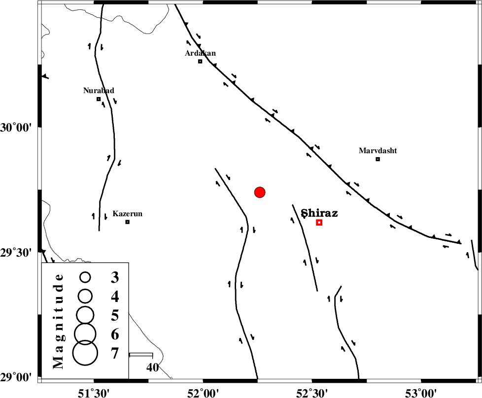
| Location | Lat:29.74 Lon: 52.26 |
| Region | Fars Province, 29 km North-West of Shiraz |
Nearest Cities |
|
| 9 km North of Khanehzanian, Fars Province | |
| 28 km South West of Baiza, Fars Province | |
| 29 km North of Richi, Fars Province | |
| 30 km North West of Shiraz, Fars Province | |
| 33 km South West of Kushk hezar, Fars Province | |
| Depth | 14 km |
| Agency | |
Faults within 150 km: |
|
| KAREBASS_F (Length: 98 km) , Distance to epicenter: 11 km | |
| SABZ_PUSHAN_F_Z3 (Length: 37 km) , Distance to epicenter: 16 km | |
| HZF3 (Length: 197 km) , Distance to epicenter: 30 km | |
| Number of Phases | 6 |
| RMS | 0.1 |
| Number of Stations | 5 |
| Error in Latitude | >6 km |
| Error in Longitude | 4.1 km |
| Error in Depth | 16.6 km |
Download waveform in seisan format
to download seisan software Click here
to access information about IIEES stations Click here
Amplitude | ||||||||
| UID | Agency | Station | Component | Amplitude | Period | Arrival Time | Proccessing Time | Signal Clip |
| 80313 | IIEES | GHIR | E | 272.5 | 0.84 | 2011-09-24 23:35:20 | 2011-09-25 05:04:00 | n |
| 80314 | IIEES | NASN | E | 53.1 | 1.02 | 2011-09-24 23:36:20 | 2011-09-25 05:04:00 | n |
Phase | ||||||||||||
| Agency | Station | Component | Phase Type | Phase Quality | First Motion | Observed Arrival Time | Time Residual | Loc. Flag | Input Weight | Distance | Azimuth | |
| IIEES | AHRM | Z | Pg | E | 2011-09-24 23:34:47 | -0.03 | y | 135 | 224 | |||
| IIEES | GHIR | Z | Pg | E | 2011-09-24 23:34:53 | 0.03 | y | 176 | 156 | |||
| IIEES | GHIR | E | Sg | E | 2011-09-24 23:35:15 | -0.01 | y | 176 | 156 | |||
| IIEES | NASN | Z | Pn | E | 2011-09-24 23:35:15 | -0.05 | y | 343 | 9 | |||
| IIEES | KHMZ | Z | Pn | E | 2011-09-24 23:35:34 | 0.25 | y | 494 | 334 | |||
| IIEES | ASAO | Z | Pn | E | 2011-09-24 23:35:43 | -0.21 | y | 573 | 339 | |||