
Magnitude |
:4.1 |
| Date & Time (UTC) | 2011-09-16 23:07:42.0 |
| Date & Time (Local) | 1390/6/26 03:37:42.0 |
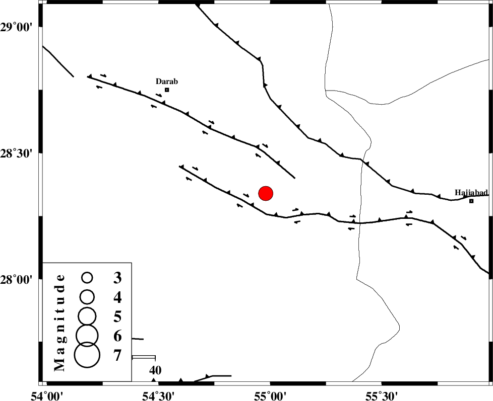
| Location | Lat:28.34 Lon: 54.98 |
| Region | Fars Province, 63 km South-East of Darab |
Nearest Cities |
|
| 15 km South of Rostaq, Fars Province | |
| 22 km North West of Doborji, Fars Province | |
| 25 km North West of Fadami, Fars Province | |
| 44 km South West of Tal bargah, Fars Province | |
| 44 km South East of Dehkheyr, Fars Province | |
| Depth | 41 km |
| Agency | |
Faults within 150 km: |
|
| HZF2 (Length: 437 km) , Distance to epicenter: 9 km | |
| HZF1 (Length: 102 km) , Distance to epicenter: 15 km | |
| MAIN_ZAGROS_R_F (Length: 1106 km) , Distance to epicenter: 31 km | |
| Number of Phases | 10 |
| RMS | 0.4 |
| Number of Stations | 8 |
| Error in Latitude | >5.9 km |
| Error in Longitude | 3 km |
| Error in Depth | 7.6 km |
Download waveform in seisan format
to download seisan software Click here
to access information about IIEES stations Click here
Amplitude | ||||||||
| UID | Agency | Station | Component | Amplitude | Period | Arrival Time | Proccessing Time | Signal Clip |
| 80242 | IIEES | BNDS | N | 1696.8 | 0.48 | 2011-09-16 23:08:37 | 2011-09-16 11:38:00 | n |
| 80243 | IIEES | GHIR | E | 4128.2 | 0.52 | 2011-09-16 23:08:42 | 2011-09-16 11:38:00 | n |
| 80244 | IIEES | TABS | N | 46.7 | 0.6 | 2011-09-16 23:11:05 | 2011-09-16 11:38:00 | n |
Phase | ||||||||||||
| Agency | Station | Component | Phase Type | Phase Quality | First Motion | Observed Arrival Time | Time Residual | Loc. Flag | Input Weight | Distance | Azimuth | |
| IIEES | BNDS | Z | Pg | E | 2011-09-16 23:08:07 | -0.21 | y | 157 | 131 | |||
| IIEES | BNDS | E | Sg | E | 2011-09-16 23:08:27 | 0.06 | y | 157 | 131 | |||
| IIEES | GHIR | Z | Pn | E | 2011-09-16 23:08:11 | 0.2 | y | 195 | 269 | |||
| IIEES | GHIR | E | Sg | E | 2011-09-16 23:08:37 | 0.06 | y | 195 | 269 | |||
| IIEES | NASN | Z | Pn | E | 2011-09-16 23:08:53 | -0.26 | y | 537 | 338 | |||
| IIEES | TABS | N | Pn | E | 2011-09-16 23:09:05 | 0.97 | y | 623 | 19 | |||
| IIEES | CHBR | Z | Pn | E | 2011-09-16 23:09:04 | -0.13 | y | 625 | 118 | |||
| IIEES | KHMZ | Z | Pn | E | 2011-09-16 23:09:22 | -0.41 | y | 766 | 323 | |||
| IIEES | GHVR | Z | Pn | E | 2011-09-16 23:09:22 | -0.45 | y | 768 | 333 | |||
| IIEES | ASAO | Z | Pn | E | 2011-09-16 23:09:30 | -0.24 | y | 834 | 327 | |||