
Magnitude |
:3.6 |
| Date & Time (UTC) | 2011-09-15 04:46:07.7 |
| Date & Time (Local) | 1390/6/24 09:16:07.7 |
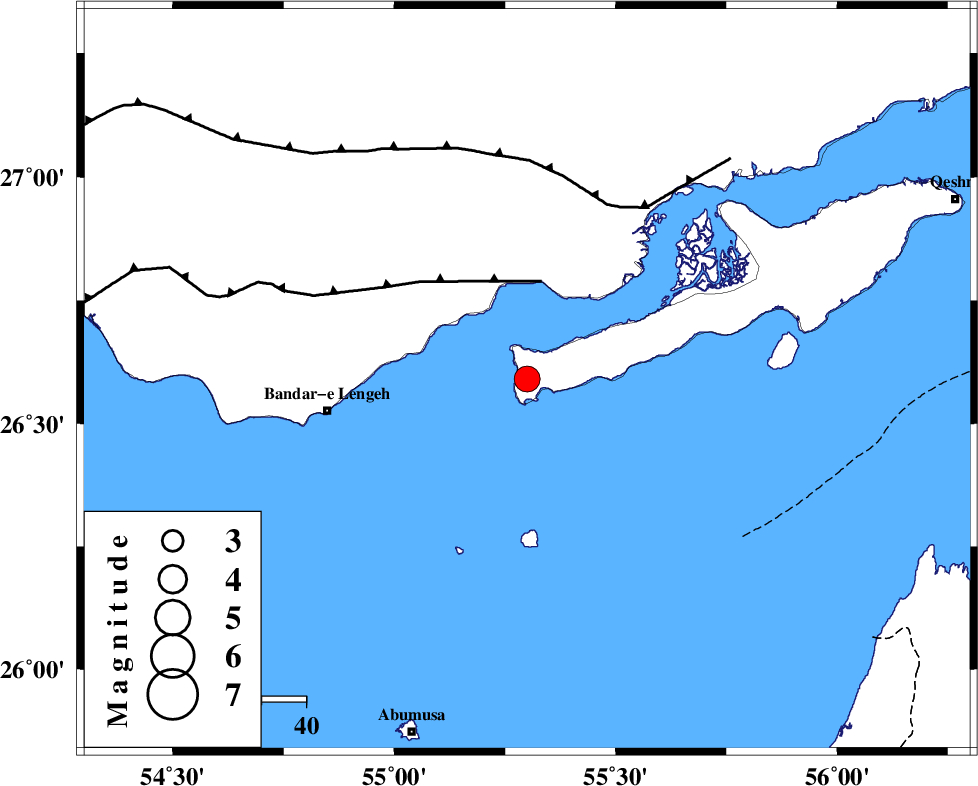
| Location | Lat:26.59 Lon: 55.3 |
| Region | Persian Gulf, 45 km East of Bandar-e lengeh |
Nearest Cities |
|
| 45 km North East of Bandar-e lengeh, Hormozgan Province | |
| 49 km South West of Bandar-e khamir, Hormozgan Province | |
| 78 km South West of Suza, Hormozgan Province | |
| 84 km North East of Abu Musa, Hormozgan Province | |
| 104 km South West of Qeshm, Hormozgan Province | |
| Depth | 31 km |
| Agency | |
Faults within 150 km: |
|
| ZFF1 (Length: 165 km) , Distance to epicenter: 22 km | |
| MFF1 (Length: 180 km) , Distance to epicenter: 43 km | |
| MFF3 (Length: 292 km) , Distance to epicenter: 123 km | |
| Number of Phases | 5 |
| RMS | 0.3 |
| Number of Stations | 4 |
| Error in Latitude | >8 km |
| Error in Longitude | 5.8 km |
| Error in Depth | 12.8 km |
Download waveform in seisan format
to download seisan software Click here
to access information about IIEES stations Click here
Amplitude | ||||||||
| UID | Agency | Station | Component | Amplitude | Period | Arrival Time | Proccessing Time | Signal Clip |
| 80238 | IIEES | BNDS | E | 2427.1 | 0.27 | 2011-09-15 04:46:49 | 2011-09-15 05:05:00 | n |
| 80239 | IIEES | GHIR | E | 104.6 | 0.45 | 2011-09-15 04:47:50 | 2011-09-15 05:05:00 | n |
Phase | ||||||||||||
| Agency | Station | Component | Phase Type | Phase Quality | First Motion | Observed Arrival Time | Time Residual | Loc. Flag | Input Weight | Distance | Azimuth | |
| IIEES | BNDS | Z | Pg | E | 2011-09-15 04:46:28 | -0.16 | y | 125 | 44 | |||
| IIEES | BNDS | N | Sg | E | 2011-09-15 04:46:43 | 0.14 | y | 125 | 44 | |||
| IIEES | GHIR | Z | Pn | E | 2011-09-15 04:46:50 | 0.23 | y | 296 | 310 | |||
| IIEES | CHBR | Z | Pn | E | 2011-09-15 04:47:19 | 0.04 | y | 530 | 101 | |||
| IIEES | NASN | Z | P | E | 2011-09-15 04:47:44 | -0.52 | y | 730 | 341 | |||