
Magnitude |
:2.5 |
| Date & Time (UTC) | 2011-09-04 19:46:48.4 |
| Date & Time (Local) | 1390/6/14 00:16:48.4 |
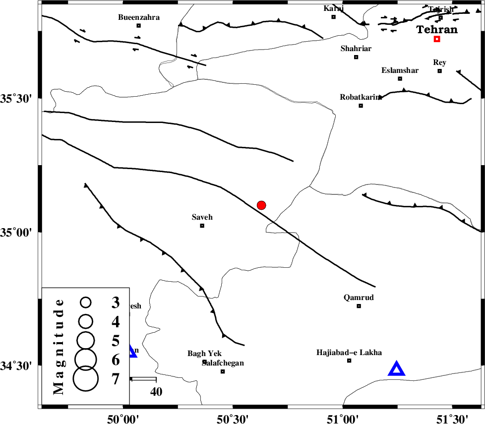
| Location | Lat:35.1 Lon: 50.63 |
| Region | Markazi Province, 26 km East of Saveh |
Nearest Cities |
|
| 18 km North East of Taraznahid, Markazi Province | |
| 24 km South East of Memunieh, Markazi Province | |
| 26 km North East of Saveh, Markazi Province | |
| 29 km South East of Hakimabad, Markazi Province | |
| 29 km South of Rahimabad, Markazi Province | |
| Depth | 32 km |
| Agency | |
Faults within 150 km: |
|
| KUSHK_E_NOSRAT_F (Length: 230 km) , Distance to epicenter: 7 km | |
| S_PARANDAK_F (Length: 116 km) , Distance to epicenter: 22 km | |
| INDES_F (Length: 98 km) , Distance to epicenter: 42 km | |
| Number of Phases | 6 |
| RMS | 0.1 |
| Number of Stations | 4 |
| Error in Latitude | >0.8 km |
| Error in Longitude | 2.1 km |
| Error in Depth | 2.9 km |
Download waveform in seisan format
to download seisan software Click here
to access information about IIEES stations Click here
Amplitude | ||||||||
| UID | Agency | Station | Component | Amplitude | Period | Arrival Time | Proccessing Time | Signal Clip |
| 80179 | IIEES | THKV | E | 145.3 | 0.16 | 2011-09-04 19:47:16 | 2011-09-05 01:31:00 | n |
| 80180 | IIEES | THKV | N | 169.7 | 0.16 | 2011-09-04 19:47:16 | 2011-09-05 01:31:00 | n |
Phase | ||||||||||||
| Agency | Station | Component | Phase Type | Phase Quality | First Motion | Observed Arrival Time | Time Residual | Loc. Flag | Input Weight | Distance | Azimuth | |
| IIEES | ASAO | Z | Pg | E | 2011-09-04 19:47:03 | 0.01 | y | 83.1 | 222 | |||
| IIEES | GHVR | Z | Pg | E | 2011-09-04 19:47:03 | -0.06 | y | 89.1 | 141 | |||
| IIEES | GHVR | E | Sg | E | 2011-09-04 19:47:15 | 0.04 | y | 89.1 | 141 | |||
| IIEES | THKV | Z | Pg | E | 2011-09-04 19:47:04 | -0.08 | y | 92.7 | 14 | |||
| IIEES | THKV | N | Sg | E | 2011-09-04 19:47:16 | 0.06 | y | 92.7 | 14 | |||
| IIEES | KHMZ | Z | Pn | E | 2011-09-04 19:47:14 | 0.02 | y | 163 | 202 | |||