
Magnitude |
:2.9 |
| Date & Time (UTC) | 2011-09-02 01:45:39.1 |
| Date & Time (Local) | 1390/6/11 06:15:39.1 |
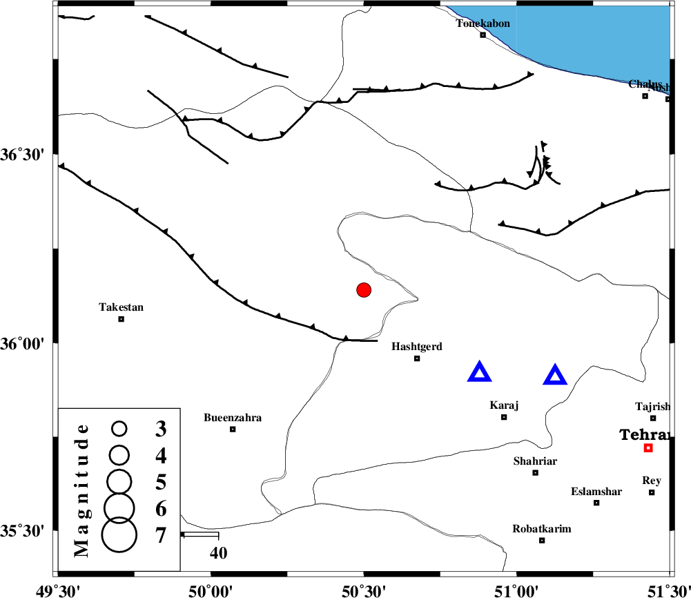
| Location | Lat:36.14 Lon: 50.5 |
| Region | Ghazvin Province, 12 km North of Abyek |
Nearest Cities |
|
| 12 km North of Abyek, Ghazvin Province | |
| 16 km West of Taleqan, Tehran Province | |
| 24 km West of Shahrak, Tehran Province | |
| 24 km North of Nazarabad-E-Bozorg, Tehran Province | |
| 26 km North West of Hashtgerd, Tehran Province | |
| Depth | 17 km |
| Agency | |
Faults within 150 km: |
|
| TALEGHAN_F (Length: 71 km) , Distance to epicenter: 6 km | |
| MOSHA_F (Length: 234 km) , Distance to epicenter: 7 km | |
| N_TEHRAN_F4 (Length: 115 km) , Distance to epicenter: 25 km | |
| Number of Phases | 6 |
| RMS | 0.1 |
| Number of Stations | 5 |
| Error in Latitude | >2.3 km |
| Error in Longitude | 2.8 km |
| Error in Depth | 2.7 km |
Download waveform in seisan format
to download seisan software Click here
to access information about IIEES stations Click here
Amplitude | ||||||||
| UID | Agency | Station | Component | Amplitude | Period | Arrival Time | Proccessing Time | Signal Clip |
| 80133 | IIEES | THKV | E | 1084.6 | 0.28 | 2011-09-02 01:45:53 | 2011-09-02 02:05:00 | n |
| 80134 | IIEES | THKV | N | 1503.7 | 0.12 | 2011-09-02 01:45:53 | 2011-09-02 02:05:00 | n |
| 80135 | IIEES | ASAO | N | 114.8 | 0.4 | 2011-09-02 01:46:32 | 2011-09-02 02:05:00 | n |
| 80136 | IIEES | GHVR | E | 91.3 | 0.24 | 2011-09-02 01:46:36 | 2011-09-02 02:05:00 | n |
Phase | ||||||||||||
| Agency | Station | Component | Phase Type | Phase Quality | First Motion | Observed Arrival Time | Time Residual | Loc. Flag | Input Weight | Distance | Azimuth | |
| IIEES | THKV | Z | Pg | E | 2011-09-02 01:45:46 | -0.03 | y | 41.9 | 126 | |||
| IIEES | ZNJK | Z | Pg | E | 2011-09-02 01:46:07 | 0.04 | y | 173 | 291 | |||
| IIEES | ASAO | Z | Pn | E | 2011-09-02 01:46:09 | 0.07 | y | 181 | 194 | |||
| IIEES | GHVR | Z | Pn | E | 2011-09-02 01:46:10 | 0.02 | y | 196 | 160 | |||
| IIEES | GHVR | N | Sg | E | 2011-09-02 01:46:34 | -0.01 | y | 196 | 160 | |||
| IIEES | SNGE | N | Pn | E | 2011-09-02 01:46:24 | -0.11 | y | 308 | 249 | |||