
Magnitude |
:3.4 |
| Date & Time (UTC) | 2011-08-27 15:02:06.2 |
| Date & Time (Local) | 1390/6/5 19:32:06.2 |
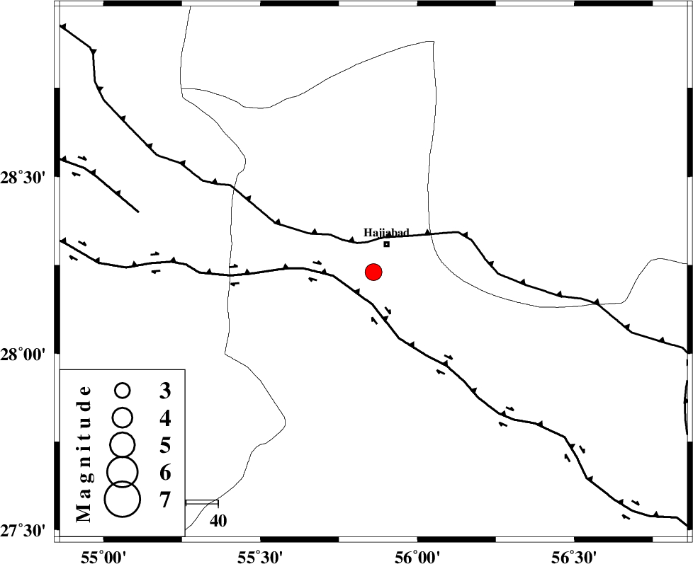
| Location | Lat:28.23 Lon: 55.86 |
| Region | Hormozgan Province, 10 km Hajiabad |
Nearest Cities |
|
| 10 km of Hajiabad, Hormozgan Province | |
| 44 km North West of Fareqan, Hormozgan Province | |
| 54 km South West of Arzuieeh, Kerman Province | |
| 57 km South West of Shahmaran, Kerman Province | |
| 59 km North East of Darz, Fars Province | |
| Depth | 6 km |
| Agency | |
Faults within 150 km: |
|
| HZF2 (Length: 437 km) , Distance to epicenter: 9 km | |
| MAIN_ZAGROS_R_F (Length: 1106 km) , Distance to epicenter: 10 km | |
| HZF1 (Length: 102 km) , Distance to epicenter: 76 km | |
| Number of Phases | 4 |
| RMS | 0.1 |
| Number of Stations | 3 |
| Error in Latitude | >5.4 km |
| Error in Longitude | 3.4 km |
| Error in Depth | 12.4 km |
Download waveform in seisan format
to download seisan software Click here
to access information about IIEES stations Click here
Amplitude | ||||||||
| UID | Agency | Station | Component | Amplitude | Period | Arrival Time | Proccessing Time | Signal Clip |
| 80107 | IIEES | BNDS | N | 1313.9 | 0.44 | 2011-08-27 15:02:41 | 2011-08-27 03:28:00 | n |
| 80108 | IIEES | BNDS | E | 1957.8 | 0.44 | 2011-08-27 15:02:41 | 2011-08-27 03:28:00 | n |
| 80109 | IIEES | GHIR | E | 131 | 0.74 | 2011-08-27 15:03:54 | 2011-08-27 03:28:00 | n |
Phase | ||||||||||||
| Agency | Station | Component | Phase Type | Phase Quality | First Motion | Observed Arrival Time | Time Residual | Loc. Flag | Input Weight | Distance | Azimuth | |
| IIEES | BNDS | Z | Pg | E | 2011-08-27 15:02:22 | -0.22 | y | 96.6 | 161 | |||
| IIEES | BNDS | E | Sg | E | 2011-08-27 15:02:35 | 0.13 | y | 96.6 | 161 | |||
| IIEES | GHIR | Z | Pn | E | 2011-08-27 15:02:49 | 0.05 | y | 282 | 272 | |||
| IIEES | ZHSF | Z | Pn | E | 2011-08-27 15:03:17 | 0.07 | y | 504 | 71 | |||