
Magnitude |
:2.9 |
| Date & Time (UTC) | 2011-08-27 01:49:19.7 |
| Date & Time (Local) | 1390/6/5 06:19:19.7 |
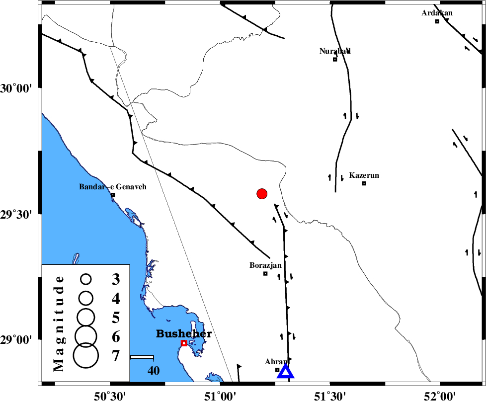
| Location | Lat:29.58 Lon: 51.19 |
| Region | Bushehr Province, 35 km North of Borazjan |
Nearest Cities |
|
| 14 km North West of Khesht, Fars Province | |
| 19 km North West of Dalki, Bushehr Province | |
| 23 km North East of Dehkohneh, Bushehr Province | |
| 23 km North of Nazar aqa, Bushehr Province | |
| 23 km North of Saedabad, Bushehr Province | |
| Depth | 14 km |
| Agency | |
Faults within 150 km: |
|
| BORAZJAN_F (Length: 168 km) , Distance to epicenter: 7 km | |
| ZFF3 (Length: 125 km) , Distance to epicenter: 19 km | |
| KAZERUN_F (Length: 96 km) , Distance to epicenter: 32 km | |
| Number of Phases | 6 |
| RMS | 0.1 |
| Number of Stations | 5 |
| Error in Latitude | >3.2 km |
| Error in Longitude | 3.4 km |
| Error in Depth | 7.3 km |
Download waveform in seisan format
to download seisan software Click here
to access information about IIEES stations Click here
Amplitude | ||||||||
| UID | Agency | Station | Component | Amplitude | Period | Arrival Time | Proccessing Time | Signal Clip |
| 80095 | IIEES | AHRM | E | 342.6 | 0.48 | 2011-08-27 01:49:48 | 2011-08-27 02:10:00 | n |
| 80096 | IIEES | GHIR | E | 207.7 | 0.56 | 2011-08-27 01:50:34 | 2011-08-27 02:10:00 | n |
| 80097 | IIEES | NASN | N | 17.7 | 0.64 | 2011-08-27 01:51:01 | 2011-08-27 02:10:00 | n |
| 80098 | IIEES | KHMZ | E | 10.8 | 0.52 | 2011-08-27 01:51:25 | 2011-08-27 02:10:00 | n |
| 80099 | IIEES | KHMZ | N | 10.7 | 0.56 | 2011-08-27 01:51:25 | 2011-08-27 02:10:00 | n |
Phase | ||||||||||||
| Agency | Station | Component | Phase Type | Phase Quality | First Motion | Observed Arrival Time | Time Residual | Loc. Flag | Input Weight | Distance | Azimuth | |
| IIEES | AHRM | Z | Pg | E | 2011-08-27 01:49:33 | -0.12 | y | 79.6 | 173 | |||
| IIEES | GHIR | Z | Pn | E | 2011-08-27 01:49:55 | 0.15 | y | 226 | 129 | |||
| IIEES | GHIR | E | Sg | E | 2011-08-27 01:50:23 | 0.02 | y | 226 | 129 | |||
| IIEES | NASN | Z | Pn | E | 2011-08-27 01:50:15 | -0.2 | y | 389 | 23 | |||
| IIEES | KHMZ | N | Pn | E | 2011-08-27 01:50:26 | 0.01 | y | 476 | 346 | |||
| IIEES | SNGE | Z | Pn | E | 2011-08-27 01:50:56 | 0.26 | y | 711 | 330 | |||