
Magnitude |
:3.7 |
| Date & Time (UTC) | 2011-08-14 23:43:00.6 |
| Date & Time (Local) | 1390/5/24 04:13:00.6 |
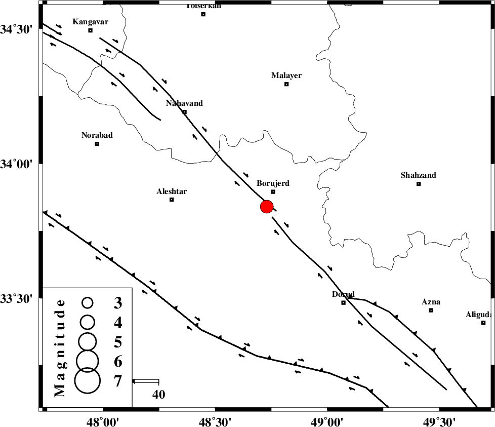
| Location | Lat:33.84 Lon: 48.73 |
| Region | Lorestan Province, 6 km Borujerd |
Nearest Cities |
|
| 6 km North of Hemmatabad, Lorestan Province | |
| 7 km of Borujerd, Lorestan Province | |
| 10 km West of Valanjerd, Lorestan Province | |
| 12 km North of Pellekan-e sofla, Lorestan Province | |
| 15 km South of Bon dizeh, Lorestan Province | |
| Depth | 16 km |
| Agency | |
Faults within 150 km: |
|
| NAHAVAND_F (Length: 102 km) , Distance to epicenter: 4 km | |
| DORUD (Length: 100 km) , Distance to epicenter: 5 km | |
| MAIN_ZAGROS_R_F (Length: 1106 km) , Distance to epicenter: 50 km | |
| Number of Phases | 7 |
| RMS | 0.1 |
| Number of Stations | 5 |
| Error in Latitude | >1.4 km |
| Error in Longitude | 1.4 km |
| Error in Depth | 3 km |
Download waveform in seisan format
to download seisan software Click here
to access information about IIEES stations Click here
Amplitude | ||||||||
| UID | Agency | Station | Component | Amplitude | Period | Arrival Time | Proccessing Time | Signal Clip |
| 79984 | IIEES | SHGR | E | 746 | 0.76 | 2011-08-14 23:44:05 | 2011-08-15 12:12:00 | n |
| 79985 | IIEES | SHGR | N | 702.3 | 0.56 | 2011-08-14 23:44:05 | 2011-08-15 12:12:00 | n |
| 79986 | IIEES | GHVR | E | 434.2 | 0.36 | 2011-08-14 23:44:17 | 2011-08-15 12:12:00 | n |
Phase | ||||||||||||
| Agency | Station | Component | Phase Type | Phase Quality | First Motion | Observed Arrival Time | Time Residual | Loc. Flag | Input Weight | Distance | Azimuth | |
| IIEES | SNGE | Z | Pg | E | 2011-08-14 23:43:31 | -0.15 | y | 188 | 318 | |||
| IIEES | SNGE | E | Sg | E | 2011-08-14 23:43:54 | 0.07 | y | 188 | 318 | |||
| IIEES | SHGR | Z | Pg | E | 2011-08-14 23:43:32 | 0.07 | y | 193 | 178 | |||
| IIEES | GHVR | Z | Pn | E | 2011-08-14 23:43:38 | 0.09 | y | 242 | 72 | |||
| IIEES | GHVR | N | Sg | E | 2011-08-14 23:44:09 | 0.01 | y | 242 | 72 | |||
| IIEES | ZNJK | Z | Pn | E | 2011-08-14 23:43:47 | 0.06 | y | 314 | 359 | |||
| IIEES | NASN | Z | Pn | E | 2011-08-14 23:43:57 | -0.18 | y | 397 | 106 | |||