
Magnitude |
:2.9 |
| Date & Time (UTC) | 2011-08-06 19:51:18.2 |
| Date & Time (Local) | 1390/5/16 00:21:18.2 |
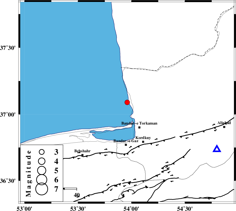
| Location | Lat:37.09 Lon: 53.96 |
| Region | Caspian Sea, 23 km North-West of Bandar-e torkaman |
Nearest Cities |
|
| 11 km West of Gomishtappeh, Golestan Province | |
| 23 km North West of Bandar-e torkaman, Golestan Province | |
| 25 km North West of Banavar, Golestan Province | |
| 27 km North West of Sijval, Golestan Province | |
| 36 km North West of Kordkuy, Golestan Province | |
| Depth | 37 km |
| Agency | |
Faults within 150 km: |
|
| KHAZAR_F (Length: 523 km) , Distance to epicenter: 37 km | |
| N_ALBORZ_F (Length: 360 km) , Distance to epicenter: 64 km | |
| SHAVAR_F (Length: 87 km) , Distance to epicenter: 70 km | |
| Number of Phases | 4 |
| RMS | 0 |
| Number of Stations | 4 |
| Error in Latitude | >3.1 km |
| Error in Longitude | 7.7 km |
| Error in Depth | 4.4 km |
Download waveform in seisan format
to download seisan software Click here
to access information about IIEES stations Click here
Amplitude | ||||||||
| UID | Agency | Station | Component | Amplitude | Period | Arrival Time | Proccessing Time | Signal Clip |
| 79929 | IIEES | MRVT | E | 145.7 | 0.04 | 2011-08-06 19:52:21 | 2011-08-06 08:16:00 | n |
| 79930 | IIEES | THKV | N | 30 | 0.26 | 2011-08-06 19:52:53 | 2011-08-06 08:16:00 | n |
Phase | ||||||||||||
| Agency | Station | Component | Phase Type | Phase Quality | First Motion | Observed Arrival Time | Time Residual | Loc. Flag | Input Weight | Distance | Azimuth | |
| IIEES | MRVT | Z | Pg | E | 2011-08-06 19:51:50 | 0 | y | 199 | 71 | |||
| IIEES | SHRO | Z | Pg | E | 2011-08-06 19:51:53 | 0 | y | 220 | 122 | |||
| IIEES | SHRO | N | Sg | E | 2011-08-06 19:52:19 | -0.01 | y | 220 | 122 | |||
| IIEES | BJRD | Z | Pn | E | 2011-08-06 19:52:02 | 0.01 | y | 313 | 76 | |||