
Magnitude |
:2.9 |
| Date & Time (UTC) | 2011-08-04 22:41:55.3 |
| Date & Time (Local) | 1390/5/14 03:11:55.3 |
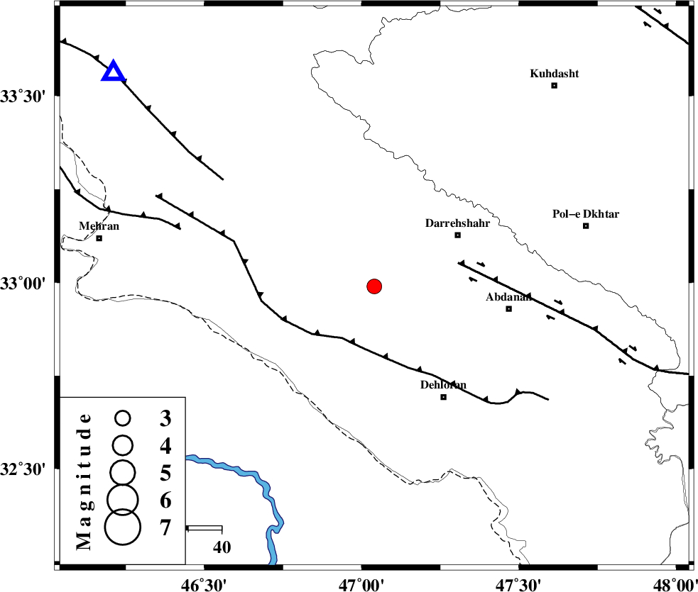
| Location | Lat:32.99 Lon: 47.04 |
| Region | Ilam Province, 29 km South-West of Darreh Shahr |
Nearest Cities |
|
| 19 km North of Bishehzar, Ilam Province | |
| 28 km South East of Meymeh, Ilam Province | |
| 29 km South West of Darreh Shahr, Ilam Province | |
| 32 km South of Badreh, Ilam Province | |
| 33 km South West of Dashtabad-e olia, Ilam Province | |
| Depth | 18 km |
| Agency | |
Faults within 150 km: |
|
| MFF6 (Length: 144 km) , Distance to epicenter: 18 km | |
| BALARUD_F_Z1 (Length: 87 km) , Distance to epicenter: 26 km | |
| MFF7 (Length: 99 km) , Distance to epicenter: 55 km | |
| Number of Phases | 5 |
| RMS | 0 |
| Number of Stations | 4 |
| Error in Latitude | >3.8 km |
| Error in Longitude | 8.2 km |
| Error in Depth | 4.5 km |
Download waveform in seisan format
to download seisan software Click here
to access information about IIEES stations Click here
Amplitude | ||||||||
| UID | Agency | Station | Component | Amplitude | Period | Arrival Time | Proccessing Time | Signal Clip |
| 79912 | IIEES | SHGR | E | 135 | 0.48 | 2011-08-04 22:43:02 | 2011-08-04 11:44:00 | n |
| 79913 | IIEES | SNGE | N | 69.2 | 0.4 | 2011-08-04 22:43:10 | 2011-08-04 11:44:00 | n |
| 79914 | IIEES | SNGE | E | 76.7 | 0.48 | 2011-08-04 22:43:10 | 2011-08-04 11:44:00 | n |
| 79915 | IIEES | GHVR | E | 14.6 | 0.64 | 2011-08-04 22:43:50 | 2011-08-04 11:44:00 | n |
Phase | ||||||||||||
| Agency | Station | Component | Phase Type | Phase Quality | First Motion | Observed Arrival Time | Time Residual | Loc. Flag | Input Weight | Distance | Azimuth | |
| IIEES | SHGR | E | Sg | E | 2011-08-04 22:42:50 | 0.04 | y | 193 | 120 | |||
| IIEES | SNGE | Z | Pn | E | 2011-08-04 22:42:31 | 0.03 | y | 235 | 7 | |||
| IIEES | SNGE | N | Sg | E | 2011-08-04 22:43:01 | 0.02 | y | 235 | 7 | |||
| IIEES | KHMZ | Z | Pn | E | 2011-08-04 22:42:38 | -0.08 | y | 285 | 72 | |||
| IIEES | GHVR | Z | Pn | E | 2011-08-04 22:42:55 | -0.03 | y | 423 | 66 | |||