
Magnitude |
:3.1 |
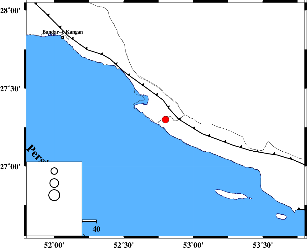
| Date & Time (UTC) | 2011-07-30 20:34:42.7 |
| Date & Time (Local) | 1390/5/9 01:04:42.7 |
| Location | Lat:27.3 Lon: 52.8 |
| Region | Hormozgan Province, 29 km South of Mehr |
Nearest Cities |
|
| 7 km of Chah-e mobarak, Bushehr Province | |
| 24 km South West of Khoozi, Fars Province | |
| 27 km South East of Bandar-e asaluyeh, Bushehr Province | |
| 29 km South of Mehr, Fars Province | |
| 32 km South of Ardavan-e olia, Fars Province | |
| Depth | 15 km |
| Agency | |
Faults within 150 km: |
|
| MFF3 (Length: 292 km) , Distance to epicenter: 8 km | |
| LAR_F (Length: 99 km) , Distance to epicenter: 113 km | |
| ZFF1 (Length: 165 km) , Distance to epicenter: 114 km | |
| Number of Phases | 3 |
| RMS | 0 |
| Number of Stations | 3 |
| Error in Latitude | >6.1 km |
| Error in Longitude | 2.6 km |
| Error in Depth | 0 km |
Download waveform in seisan format
to download seisan software Click here
to access information about IIEES stations Click here
Amplitude | ||||||||
| UID | Agency | Station | Component | Amplitude | Period | Arrival Time | Proccessing Time | Signal Clip |
| 79862 | IIEES | GHIR | N | 631.2 | 0.21 | 2011-07-30 20:35:21 | 2011-07-30 09:02:00 | n |
| 79863 | IIEES | GHIR | E | 415.9 | 0.35 | 2011-07-30 20:35:22 | 2011-07-30 09:02:00 | n |
| 79864 | IIEES | AHRM | N | 128.1 | 0.44 | 2011-07-30 20:36:06 | 2011-07-30 09:02:00 | n |
Phase | ||||||||||||
| Agency | Station | Component | Phase Type | Phase Quality | First Motion | Observed Arrival Time | Time Residual | Loc. Flag | Input Weight | Distance | Azimuth | |
| IIEES | GHIR | Z | Pg | E | 2011-07-30 20:35:01 | 0 | y | 110 | 10 | |||
| IIEES | AHRM | Z | Pg | E | 2011-07-30 20:35:19 | 0 | y | 227 | 320 | |||
| IIEES | KRBR | Z | Pn | E | 2011-07-30 20:35:51 | 0 | y | 488 | 52 | |||